Home > Europe > Italy > Maps
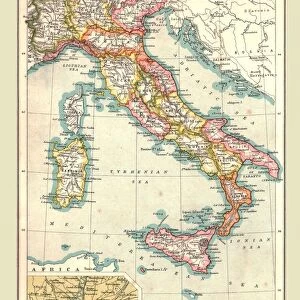
Ptolemaic Map of Italy, 1482 (coloured litho)
")
![]()
Wall Art and Photo Gifts from Fine Art Finder
Ptolemaic Map of Italy, 1482 (coloured litho)
STC221897 Ptolemaic Map of Italy, 1482 (coloured litho) by Germanus, Nicolaus (fl.1464-71); Private Collection; (add.info.: based on cartography from Geographica by Ptolemy (Claudius Ptolemaeus of Alexandria) (c.90-168 AD); Germanus was first cartographer to use trapezoidal projection to reduce distortion in longitudinal distances; ); The Stapleton Collection; German, out of copyright
Media ID 23210278
© The Stapleton Collection / Bridgeman Images
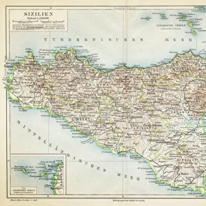
Corsica Mapmaker Mapmaking Mediterranean Sea Sardinia
FEATURES IN THESE COLLECTIONS
> Europe
> Italy
> Sardinia
> Related Images
> Fine Art Finder
> Artists
> Greek School
> Fine Art Finder
> Maps (celestial & Terrestrial)
> Maps and Charts
> Italy
> Maps and Charts
> Related Images
EDITORS COMMENTS
This print showcases the "Ptolemaic Map of Italy, 1482" by Nicolaus Germanus. A true masterpiece of cartography, this coloured lithograph is a testament to the skill and precision of its creator. Based on the ancient Geographica by Ptolemy, a renowned Greek mathematician and geographer from Alexandria, this map provides a fascinating glimpse into Italy's geographical landscape during that era. The intricate details depict not only the Italian peninsula but also neighboring regions such as Sardinia and Corsica. What sets Germanus' work apart is his innovative use of trapezoidal projection to minimize distortion in longitudinal distances. This groundbreaking technique revolutionized mapmaking at the time and further enhanced the accuracy of his depiction. The vibrant colors breathe life into this historical artifact, transporting viewers back in time to an age when exploration and discovery were paramount. As we gaze upon this remarkable piece, we can almost feel ourselves sailing across the Mediterranean Sea alongside ancient mariners. Preserved within a private collection known as The Stapleton Collection, this particular print captures both artistry and scientific ingenuity. It serves as a reminder that maps are not merely tools for navigation but also works of art that reflect our ever-evolving understanding of our world's geography. Bridgeman Images has done justice to this extraordinary piece with their expert photography skills, allowing us to appreciate every intricate detail from afar while immersing ourselves in history's rich tapestry.
MADE IN THE USA
Safe Shipping with 30 Day Money Back Guarantee
FREE PERSONALISATION*
We are proud to offer a range of customisation features including Personalised Captions, Color Filters and Picture Zoom Tools
SECURE PAYMENTS
We happily accept a wide range of payment options so you can pay for the things you need in the way that is most convenient for you
* Options may vary by product and licensing agreement. Zoomed Pictures can be adjusted in the Cart.