Home > Arts > Cubist sculptures > Abstract art > Modern art
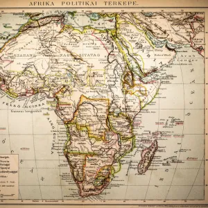
East Guinea containing the Kingdoms of Loango, Congo, Angola and Benguela, engraving by G. Zuliani taken from Tome IV of the "Newest Atlas"published in Venice in 1784 by Antonio Zatta, Private Collection

![]()
Wall Art and Photo Gifts from Fine Art Finder
East Guinea containing the Kingdoms of Loango, Congo, Angola and Benguela, engraving by G. Zuliani taken from Tome IV of the "Newest Atlas"published in Venice in 1784 by Antonio Zatta, Private Collection
3572582 East Guinea containing the Kingdoms of Loango, Congo, Angola and Benguela, engraving by G. Zuliani taken from Tome IV of the " Newest Atlas" published in Venice in 1784 by Antonio Zatta, Private Collection by Zuliani, G. (18th century); (add.info.: Artist: Zuliani G.
Date of Artwork: 1784
Location: Florence
Photographer: Alinari); Alinari Archives, Florence
Media ID 22971262
© Alinari Archives, Florence / Bridgeman Images
Abstract Concept And Symbol Cartography Communication And Publicity Concept Or Subject Expressed Drawing And Graphics Geographical Or Topographical Map Graphics Instrument And Document Movable Modern Work Renaissance Baroque Styles And Periods Scene Means Of Communication Territory
FEATURES IN THESE COLLECTIONS
> Abstract Art
> Painting
> Related Images
> Africa
> Angola
> Related Images
> Arts
> Abstract art
> Arts
> Art Movements
> Baroque
> Arts
> Contemporary art
> Modern art
> Abstract art
> Arts
> Cubist sculptures
> Abstract art
> Modern art
> Arts
> Still life artwork
> Abstract art
> Fine art
> Fine Art Finder
> Artists
> G. Zuliani
EDITORS COMMENTS
This print showcases an exquisite engraving by G. Zuliani, taken from Tome IV of the "Newest Atlas" published in Venice in 1784 by Antonio Zatta. Titled "East Guinea containing the Kingdoms of Loango, Congo, Angola and Benguela" this piece offers a glimpse into the intricate cartography of the eighteenth century. The artwork transports us back to a time when maps were not only instruments for navigation but also works of art. With its renaissance baroque style and attention to detail, it captures the essence of geographical exploration during this period. The map itself is a testament to human curiosity and discovery. It depicts vast territories with precision, showcasing kingdoms such as Loango, Congo, Angola, and Benguela. Through this visual representation, we can appreciate how communication and publicity played crucial roles in shaping our understanding of different regions. Beyond its historical significance, this engraving holds symbolic value as well. It serves as an abstract concept that bridges geography with artistry – merging graphics with writing to create a movable modern work that transcends time. Preserved within private collections like Bridgeman Images' Fine Art Finder collection, these engravings remind us of Europe's rich cultural heritage while offering insights into early forms of communication through visuals. As we admire this masterpiece from Florence's Alinari Archives today, let it serve as a reminder that even centuries-old artworks continue to inspire awe and fascination in our modern world.
MADE IN THE USA
Safe Shipping with 30 Day Money Back Guarantee
FREE PERSONALISATION*
We are proud to offer a range of customisation features including Personalised Captions, Color Filters and Picture Zoom Tools
SECURE PAYMENTS
We happily accept a wide range of payment options so you can pay for the things you need in the way that is most convenient for you
* Options may vary by product and licensing agreement. Zoomed Pictures can be adjusted in the Cart.