
Maps Collection
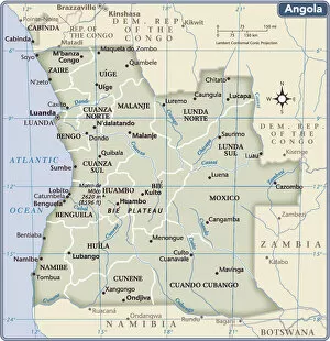
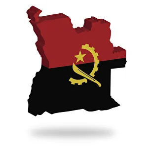
Angola is a country located in south-central Africa, bordered by Namibia to the south, Zambia to the east, and the Democratic Republic of Congo to the north
Choose a picture from our Maps Collection for your Wall Art and Photo Gifts
27 items


All Professionally Made to Order for Quick Shipping
-
Maps Collection
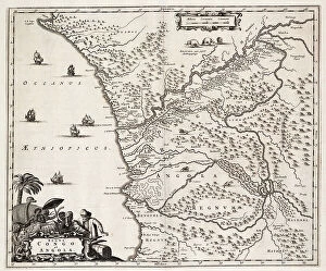
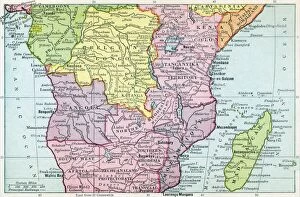
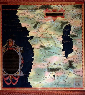
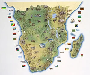
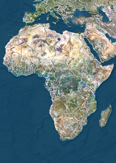
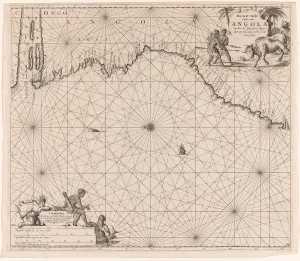
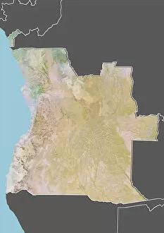
Angola is a country located in south-central Africa, bordered by Namibia to the south, Zambia to the east, and the Democratic Republic of Congo to the north. Angola has a rich history and culture that dates back centuries. Maps of Angola are an important tool for understanding this country's geography and its people. These maps provide detailed information about its cities, towns, rivers, mountains, roads, national parks and other features. They also show political boundaries such as provinces and districts as well as international borders with neighboring countries. Maps of Angola can be used for research purposes or simply for exploring this fascinating African nation.
+
Our beautiful pictures are available as Framed Prints, Photos, Wall Art and Photo Gifts
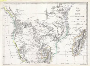
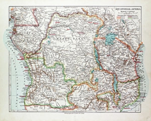
Media Storehouse offers a collection of Maps of Angola Africa, which includes wall art and framed prints. Our collection features maps that showcase the geography, topography, and political boundaries of Angola. These maps are perfect for those who want to learn more about the country's history or for those who have an interest in cartography. The Maps of Angola Africa collection is diverse and includes vintage maps from as early as the 17th century to modern-day digital maps. Some of the featured maps include detailed depictions of major cities such as Luanda, Benguela, and Lobito. Others highlight important landmarks like rivers, mountains, national parks, and wildlife reserves. These high-quality prints are available in various sizes to suit different preferences and spaces. They make great additions to homes or offices with an African theme or anyone looking for unique decor pieces that spark conversation. Our Maps of Angola Africa collection provides a fascinating glimpse into one of Africa's most intriguing countries through its rich cartographic history.
+
What are Maps of Angola Africa art prints?
Maps of Angola Africa art prints are a collection of beautifully crafted and detailed maps that showcase the geography, topography, and landmarks of Angola. These prints are created using high-quality printing techniques to ensure that every detail is captured with precision and clarity. They come in various sizes, making them perfect for both personal and commercial use. These art prints offer an excellent way to explore the rich culture and history of Angola while adding a touch of sophistication to any space. Whether you're looking to decorate your home or office, Maps of Angola Africa art prints provide a unique way to showcase your love for travel, adventure, and exploration. In addition to their aesthetic appeal, these maps also serve as valuable educational tools. They can be used by students or researchers who want to learn more about the country's geography or history. Maps of Angola Africa art prints are a must-have for anyone who loves beautiful artwork that tells a story about one of Africa's most fascinating countries.
+
What Maps of Angola Africa art prints can I buy from Media Storehouse?
We offer a wide range of Maps of Angola Africa art prints that are perfect for anyone interested in the geography and history of this African nation. These maps come in various sizes, styles, and formats to suit different tastes and preferences. You can choose from vintage maps that showcase the country's colonial past or modern ones that highlight its current political boundaries. Some popular options include detailed topographical maps that show Angola's diverse landscapes, including mountains, rivers, forests, and deserts. There are also thematic maps that focus on specific aspects such as population density, natural resources, or transportation networks. Whether you're an avid collector or simply looking for a unique piece of wall art to decorate your home or office space with, we have something for everyone. With high-quality printing technology and premium materials used in all their products' production processes ensure these Map prints will last you a lifetime.
+
How do I buy Maps of Angola Africa art prints?
To buy Maps of Angola Africa art prints from Media Storehouse, you can browse our extensive collection of maps and select the one that catches your eye. Once you have found the map print you want to purchase, simply add it to your cart and proceed to checkout. You will be prompted to enter your shipping information and payment details before finalizing your order. We offer a variety of sizes for their art prints, so make sure to choose the size that best fits your needs. We also offer different paper options such as matte or glossy finishes. If you have any questions about purchasing Maps of Angola Africa art prints from Media Storehouse, our customer service team is available to assist you via email or phone. With high-quality printing techniques and a vast selection of maps available, Media Storehouse makes it easy for anyone to own a beautiful piece of artwork depicting Angola's geography.
+
How much do Maps of Angola Africa art prints cost?
We offer a wide range of Maps of Angola Africa art prints that are available for purchase. The cost of these prints varies depending on the size and type of print you choose. We have a variety of options including canvas prints, framed prints, and poster prints. Our prices are competitive and affordable, making it easy for you to find the perfect piece to add to your collection or decorate your home or office. Our Maps of Angola Africa art prints showcase stunning images that capture the beauty and diversity of this African country. From detailed maps highlighting its geography to artistic interpretations showcasing its culture and history, our selection has something for everyone. We take pride in providing high-quality products that meet our customers' expectations while also offering excellent value for their money. So if you're looking for beautiful Maps of Angola Africa art prints at an affordable price, look no further than Media Storehouse.
+
How will my Maps of Angola Africa art prints be delivered to me?
Your Maps of Angola Africa art prints will be delivered to you in a safe and secure manner. We take great care in packaging your artwork so that it arrives at your doorstep undamaged. Our team uses high-quality materials to ensure that your print is protected during transit. We offer various delivery options depending on your location, including standard shipping and express delivery. You can track the progress of your order through our online portal once it has been dispatched. Our goal is to provide you with a hassle-free shopping experience, which includes timely delivery of your artwork. If for any reason there are delays or issues with the shipment, we will notify you immediately and work towards resolving the problem as quickly as possible. We guarantee that your Maps of Angola Africa art prints will arrive safely and securely at your chosen address within the specified timeframe.