Home > Europe > Germany > Maps
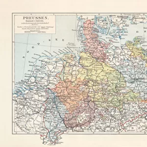
Map of the Prussian States in 1799 (print)
")
![]()
Wall Art and Photo Gifts from Fine Art Finder
Map of the Prussian States in 1799 (print)
XPH312456 Map of the Prussian States in 1799 (print) by German School; Staatsbibliothek, Berlin, Germany; (add.info.: Generalkarte der preussischen Staaten von 1799; ); out of copyright.
possible copyright restrictions apply, consult national copyright laws
Media ID 18255019
© Staatsbibliothek, Berlin, Germany / Bridgeman Images
Baltic Sea Geographical North Sea Region Territory Prussia
FEATURES IN THESE COLLECTIONS
> Arts
> Artists
> Related Images
> Fine Art Finder
> Artists
> G
> German School German School
EDITORS COMMENTS
This print showcases a historical treasure - the Map of the Prussian States in 1799. Created by the German School, this master sheet offers a detailed and comprehensive view of the territory that constituted Prussia during that era. The map, held at Staatsbibliothek in Berlin, Germany, serves as an invaluable resource for scholars and history enthusiasts alike. With its intricate cartography, this print provides a glimpse into the political and geographical landscape of Prussia at the end of the 18th century. From its borders along the Baltic Sea to its reach towards the North Sea, every region is meticulously depicted on this remarkable piece. The significance of this map extends beyond its aesthetic appeal; it represents an important historic state that played a crucial role in shaping European politics. As one explores each detail on this print - from major cities to smaller towns - they can trace Prussia's influence across vast territories. While copyright restrictions may apply due to potential national laws, viewers are fortunate enough to have access to this out-of-copyright image through Fine Art Finder. Whether used for educational purposes or personal appreciation, this print offers an opportunity to delve into Prussian history and gain insight into how boundaries were defined during that time period. In summary, this Map of the Prussian States in 1799 is not just a visual delight but also a valuable tool for understanding Europe's past geopolitical dynamics.
MADE IN THE USA
Safe Shipping with 30 Day Money Back Guarantee
FREE PERSONALISATION*
We are proud to offer a range of customisation features including Personalised Captions, Color Filters and Picture Zoom Tools
SECURE PAYMENTS
We happily accept a wide range of payment options so you can pay for the things you need in the way that is most convenient for you
* Options may vary by product and licensing agreement. Zoomed Pictures can be adjusted in the Cart.