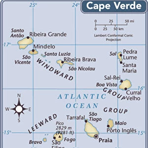
Home > Africa > Cape Verde > Maps
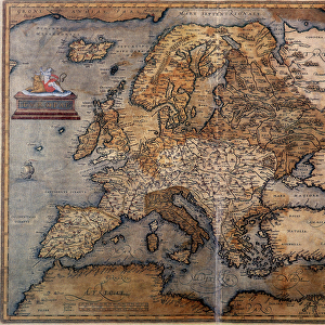
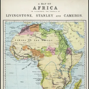
Map of Africa from William Blaeus Atlas. At the top are the cities of Tangier, ceuta

![]()
Wall Art and Photo Gifts from Fine Art Finder
Map of Africa from William Blaeus Atlas. At the top are the cities of Tangier, ceuta
GIA4804809 Map of Africa from William Blaeus Atlas. At the top are the cities of Tangier, ceuta, Algiers, Tunis, Alexandria, Alcair, Mozambique, Saint Georges de la Mina, Canary Islands. Various islands are also represented off Africa, the Mascareignes Islands, Madagascar, the Cape Verde Islands, Madere (Madeira), the Canary Islands. 1635 by Unknown Artist, (17th century); Private Collection; (add.info.: Map of Africa from William Blaeus Atlas. At the top are the cities of Tangier, ceuta, Algiers, Tunis, Alexandria, Alcair, Mozambique, Saint Georges de la Mina, Canary Islands. Various islands are also represented off Africa, the Mascareignes Islands, Madagascar, the Cape Verde Islands, Madere (Madeira), the Canary Islands. 1635); eGiancarlo Costa; out of copyright
Media ID 22289872
© Giancarlo Costa / Bridgeman Images
FEATURES IN THESE COLLECTIONS
> Africa
> Cape Verde
> Maps
> Africa
> Madagascar
> Maps
> Africa
> Mozambique
> Maps
> Arts
> Artists
> Related Images
> Fine Art Finder
> Artists
> French School
> Fine Art Finder
> Artists
> Unknown Artist
EDITORS COMMENTS
This print showcases a stunning Map of Africa from William Blaeus Atlas, dating back to the 17th century. The intricate details and vibrant colors bring this historical piece to life. At the top of the map, we can see the cities of Tangier, Ceuta, Algiers, Tunis, Alexandria, Alcair, Mozambique, Saint Georges de la Mina, and Canary Islands marked with precision. What makes this map truly fascinating are the various islands represented off the coast of Africa. From Mascareignes Islands to Madagascar and Cape Verde Islands to Madere (Madeira), each island is carefully depicted in its rightful place. The unknown artist behind this masterpiece has beautifully captured not only the geographical features but also a sense of wonder and exploration that characterized that era. It serves as a reminder of how maps were once invaluable tools for navigation and discovery. Preserved in a private collection today, this Map of Africa offers us a glimpse into history while showcasing Africa's vastness and diversity. Whether you appreciate it for its artistic merit or use it as an educational resource on African geography, this print is sure to captivate anyone with an interest in cartography or African culture.
MADE IN THE USA
Safe Shipping with 30 Day Money Back Guarantee
FREE PERSONALISATION*
We are proud to offer a range of customisation features including Personalised Captions, Color Filters and Picture Zoom Tools
SECURE PAYMENTS
We happily accept a wide range of payment options so you can pay for the things you need in the way that is most convenient for you
* Options may vary by product and licensing agreement. Zoomed Pictures can be adjusted in the Cart.