Home > Europe > France > Maps
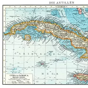
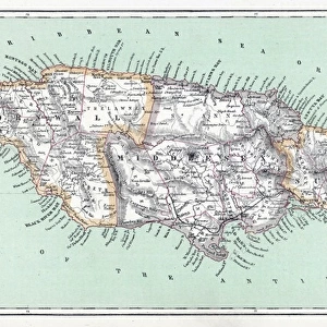
Map of Mexico and Florida (USA) with the Caribbean Islands (Cuba, Haiti, Jamaica
 with the Caribbean Islands (Cuba, Haiti, Jamaica")
![]()
Wall Art and Photo Gifts from Fine Art Finder
Map of Mexico and Florida (USA) with the Caribbean Islands (Cuba, Haiti, Jamaica
LRI4707037 Map of Mexico and Florida (USA) with the Caribbean Islands (Cuba, Haiti, Jamaica, Antilles) (etching, 1730) by Delisle, Guillaume (1675-1726); Private Collection; (add.info.: Map of Mexico and Florida (USA) with the Caribbean Islands (Cuba, Haiti, Jamaica, Antilles) - Strong water extracted from the " New Atlas containing all parts of the world" 1730 by Guillaume de L Isle (1675-1726)); Luisa Ricciarini; French, out of copyright
Media ID 23327030
© Luisa Ricciarini / Bridgeman Images
Atlas Book Caribbean Central America Cuba Cuban Geographical Map Haiti Jamaica Jamaican Mexican Mexico
FEATURES IN THESE COLLECTIONS
> Fine Art Finder
> Artists
> Franz Hogenberg
> Fine Art Finder
> Artists
> Guillaume Delisle
> Maps and Charts
> Related Images
> Maps and Charts
> World
> North America
> Cuba
> Maps
> North America
> Cuba
> Related Images
> North America
> Haiti
> Maps
> North America
> Haiti
> Related Images
> North America
> Jamaica
> Maps
EDITORS COMMENTS
This print showcases a remarkable historical artifact - the "Map of Mexico and Florida (USA) with the Caribbean Islands". Created in 1730 by Guillaume de L'Isle, a renowned French cartographer, this etching offers a glimpse into the intricate geography of the time. The map encompasses not only Mexico and Florida but also highlights significant Caribbean islands such as Cuba, Haiti, Jamaica, and Antilles. The attention to detail is evident in every stroke of this engraving. It was extracted from de L'Isle's esteemed work called "New Atlas containing all parts of the world" which solidifies its significance as an invaluable piece of history. This particular print is part of a private collection owned by Luisa Ricciarini. As we explore this map, we are transported back to the 18th century when North America and Central America were still developing regions. The inclusion of Cuba, Haiti, Jamaica, and other islands emphasizes their importance within the broader context of American geography. Luisa Ricciarini has skillfully captured this stunning image that not only serves as a geographical reference but also evokes curiosity about our past. It reminds us how maps have always been powerful tools for exploration and understanding our world's diverse landscapes.
MADE IN THE USA
Safe Shipping with 30 Day Money Back Guarantee
FREE PERSONALISATION*
We are proud to offer a range of customisation features including Personalised Captions, Color Filters and Picture Zoom Tools
SECURE PAYMENTS
We happily accept a wide range of payment options so you can pay for the things you need in the way that is most convenient for you
* Options may vary by product and licensing agreement. Zoomed Pictures can be adjusted in the Cart.