Home > Asia > Israel > Maps
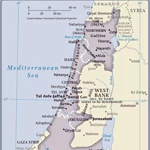
Map of the Holy Land, pub. by Jan Barend Elwe, Amsterdam, 1742 (engraving)
")
![]()
Wall Art and Photo Gifts from Fine Art Finder
Map of the Holy Land, pub. by Jan Barend Elwe, Amsterdam, 1742 (engraving)
STC101844 Map of the Holy Land, pub. by Jan Barend Elwe, Amsterdam, 1742 (engraving) by Dutch School, (18th century); Private Collection; The Stapleton Collection; Dutch, out of copyright
Media ID 23217996
© The Stapleton Collection / Bridgeman Images
Galilee Israel Judea Mediterranean Samaria
FEATURES IN THESE COLLECTIONS
> Asia
> Israel
> Related Images
> Europe
> France
> Canton
> Landes
> Fine Art Finder
> Artists
> Dutch School
> Fine Art Finder
> Artists
> English School
> Fine Art Finder
> Maps (celestial & Terrestrial)
> Maps and Charts
> Related Images
EDITORS COMMENTS
This print showcases a remarkable piece of cartographic history - the "Map of the Holy Land" published by Jan Barend Elwe in Amsterdam, 1742. Crafted with intricate precision and engraved by the skilled hands of Dutch School artists from the 18th century, this map is a testament to their mastery. The viewer is transported back in time as they explore every detail meticulously etched onto this ancient engraving. From the Dead Sea to Galilee, from Israel to Judea and Samaria, every significant landmark of this sacred land is beautifully depicted. The Mediterranean Sea glistens on one side, offering a glimpse into its vastness and importance for trade and exploration during that era. As we delve deeper into this historical treasure trove, it becomes evident that each stroke tells a story. This map not only serves as an invaluable geographical reference but also provides insight into the cultural significance attached to these lands throughout centuries. Preserved within a private collection belonging to The Stapleton Collection, this rare find has stood the test of time while retaining its allure and charm. With no commercial use intended for this image captured by Bridgeman Images, it allows us to appreciate artistry at its finest without any distractions or ulterior motives. In essence, through this photo print, we are granted access to an extraordinary artifact that connects us with our past - reminding us of how maps have shaped our understanding of geography while simultaneously reflecting societal beliefs and aspirations across generations.
MADE IN THE USA
Safe Shipping with 30 Day Money Back Guarantee
FREE PERSONALISATION*
We are proud to offer a range of customisation features including Personalised Captions, Color Filters and Picture Zoom Tools
SECURE PAYMENTS
We happily accept a wide range of payment options so you can pay for the things you need in the way that is most convenient for you
* Options may vary by product and licensing agreement. Zoomed Pictures can be adjusted in the Cart.