Home > Europe > Germany > Maps
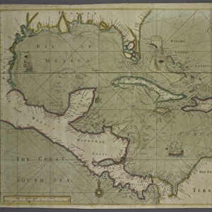
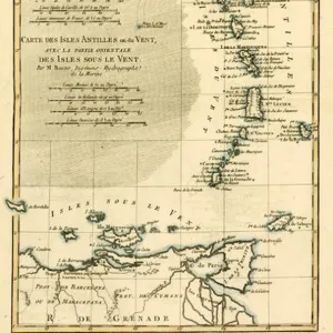
Map of the Caribbean, 1715 (hand-coloured engraving)
")
![]()
Wall Art and Photo Gifts from Fine Art Finder
Map of the Caribbean, 1715 (hand-coloured engraving)
945081 Map of the Caribbean, 1715 (hand-coloured engraving) by Moll, Hermann (fl.1678-1732); HistoryMiami, Florida, USA; eHistoryMiami; German, out of copyright
Media ID 22743168
© HistoryMiami / Bridgeman Images
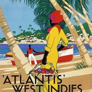
Americas Caribbean Central America Gulf Of Mexico History Miami Isthmus Of Panama New World West Indies
FEATURES IN THESE COLLECTIONS
> Fine Art Finder
> Artists
> Abraham Ortelius
> Fine Art Finder
> Artists
> Hermann Moll
> Fine Art Finder
> Maps (celestial & Terrestrial)
> Maps and Charts
> World
> North America
> Mexico
> Related Images
> North America
> Panama
> Maps
> North America
> Panama
> Related Images
> North America
> United States of America
> Florida
> Miami
> North America
> United States of America
> Florida
> Related Images
> North America
> United States of America
> Maps
EDITORS COMMENTS
This hand-coloured engraving, titled "Map of the Caribbean, 1715" takes us on a journey back in time to the era of exploration and discovery. Created by Hermann Moll, a German cartographer who lived from 1678 to 1732, this intricate map showcases the beauty and complexity of the Caribbean region. The vibrant colors bring life to each island and coastline depicted on the map. From Cuba to Jamaica, Puerto Rico to Barbados, every detail is meticulously portrayed. The Isthmus of Panama stands out as a crucial connection between Central America and South America. As we gaze upon this historical piece at HistoryMiami in Florida, USA, we are reminded of the significant role that these islands played during this period. The West Indies served as pivotal trading posts for European powers vying for control over valuable resources such as sugar cane and spices. This map not only provides geographical information but also offers insight into the mindset of explorers during that time. It represents their curiosity about new lands across the Atlantic Ocean - an uncharted territory known as the New World. With its rich history intertwined with tales of conquests and cultural exchange, this engraving serves as a reminder of our collective past. It invites us to reflect on how exploration shaped our understanding of geography while acknowledging both its triumphs and complexities. As we admire this remarkable print from Bridgeman Images' collection at Fine Art Finder, let it transport us back centuries ago when brave sailors embarked on daring expeditions
MADE IN THE USA
Safe Shipping with 30 Day Money Back Guarantee
FREE PERSONALISATION*
We are proud to offer a range of customisation features including Personalised Captions, Color Filters and Picture Zoom Tools
SECURE PAYMENTS
We happily accept a wide range of payment options so you can pay for the things you need in the way that is most convenient for you
* Options may vary by product and licensing agreement. Zoomed Pictures can be adjusted in the Cart.