Home > Asia > Israel > Maps
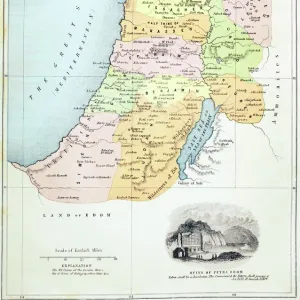
Map showing the land of the Hebrews. From A Short History of the World, published c. 1936

![]()
Wall Art and Photo Gifts from Design Pics
Map showing the land of the Hebrews. From A Short History of the World, published c. 1936
Map showing the land of the Hebrews. From A Short History of the World, published c.1936
Design Pics offers Distinctively Different Imagery representing over 1,500 contributors
Media ID 24907585
© Ken Welsh
Cartography Countries Geographical Geography Israel Land Mapmaking Maps Hebrew Hebrews Judah Philistia Phoenicia Sinai Peninsula
FEATURES IN THESE COLLECTIONS
> Asia
> Israel
> Related Images
> Maps and Charts
> Early Maps
> Maps and Charts
> Related Images
> Maps and Charts
> World
EDITORS COMMENTS
This vintage map, dating back to 1936, offers a fascinating glimpse into the land of the Hebrews. Taken from "A Short History of the World" this archival print showcases the intricate cartography and historical significance of this region. The map depicts various countries and regions that were integral to Hebrew history, including Israel, Philistia, Phoenicia, Judah, and the Sinai Peninsula. Each area is carefully illustrated with detailed engravings that capture its geographical features and cultural landmarks. As we explore this piece of artistry by Ken Welsh from Design Pics, we are transported back in time to an era when mapmaking was both a science and an art form. The meticulous attention to detail allows us to visualize how these ancient lands were divided during this period. Beyond its aesthetic appeal, this vintage map serves as a valuable educational resource for those interested in studying Hebrew history or understanding the roots of modern-day Israel. It provides a visual representation of how these territories shaped the development and identity of the Hebrew people. Whether you're an avid collector or simply appreciate historical illustrations like this one, owning a print of "Map showing the land of the Hebrews" adds depth and character to any space while offering insight into our rich human heritage.
MADE IN THE USA
Safe Shipping with 30 Day Money Back Guarantee
FREE PERSONALISATION*
We are proud to offer a range of customisation features including Personalised Captions, Color Filters and Picture Zoom Tools
SECURE PAYMENTS
We happily accept a wide range of payment options so you can pay for the things you need in the way that is most convenient for you
* Options may vary by product and licensing agreement. Zoomed Pictures can be adjusted in the Cart.