Home > Maps and Charts > Related Images
Framed Print : Cooks Map of Tahiti


![]()
Framed Photos from Mary Evans Picture Library
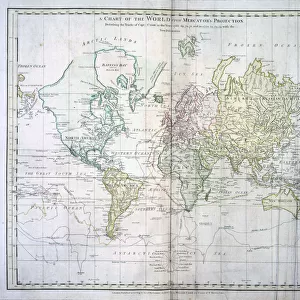
Cooks Map of Tahiti
Cooks map of Tahiti. Date: 1769
Mary Evans Picture Library makes available wonderful images created for people to enjoy over the centuries
Media ID 7111483
© Mary Evans Picture Library 2015 - https://copyrighthub.org/s0/hub1/creation/maryevans/MaryEvansPictureID/10011953
22"x18" Modern Frame
Introducing the captivating addition to your home decor, the Media Storehouse Framed Print of Cook's Map of Tahiti. This exquisite piece, sourced from Mary Evans Prints Online, dates back to 1769 and is an authentic reproduction of Captain James Cook's renowned chart of the Polynesian island. The detailed map, showcasing Tahiti's breathtaking landscapes and intricate waterways, is a testament to the rich historical significance of Cook's voyages. Hang this beautiful framed print in your living room, office, or study to add an element of timeless adventure and intrigue to your space. Each print is carefully framed with a high-quality matte finish to preserve the vibrant colors and intricate details of the map. Elevate your home or workplace with a piece of history that will surely spark conversation. Order your Media Storehouse Framed Print of Cook's Map of Tahiti today and bring a piece of the past into your present.
20x16 Print in an MDF Wooden Frame with 180 gsm Satin Finish Paper. Glazed using shatter proof thin plexiglass. Frame thickness is 1 inch and depth 0.75 inch. Fluted cardboard backing held with clips. Supplied ready to hang with sawtooth hanger and rubber bumpers. Spot clean with a damp cloth. Packaged foam wrapped in a card.
Contemporary Framed and Mounted Prints - Professionally Made and Ready to Hang
Estimated Image Size (if not cropped) is 50.8cm x 45.7cm (20" x 18")
Estimated Product Size is 55.9cm x 45.7cm (22" x 18")
These are individually made so all sizes are approximate
Artwork printed orientated as per the preview above, with landscape (horizontal) orientation to match the source image.
EDITORS COMMENTS
Cook's Map of Tahiti: A Testament to Pacific Exploration in 1769 This print depicts Captain James Cook's detailed chart of the island of Tahiti, created during his historic voyage to the Pacific Ocean in 1769. Cook, a British explorer and navigator, is renowned for his groundbreaking discoveries and explorations in the Pacific. The map, titled 'A Plan of the Harbour of Matavai in the Island of Otaheite,' offers a fascinating glimpse into the geographical knowledge of the time. Cook's meticulous charting of the harbor and surrounding area reflects the advancements in cartography and navigational techniques during the Age of Discovery. The image reveals the natural beauty of Tahiti, with its lush vegetation, pristine beaches, and crystal-clear waters. Cook's expedition marked a significant turning point in the European exploration of the Pacific, leading to further discoveries, cultural exchanges, and the establishment of colonial outposts in the region. The events of Cook's visit to Tahiti are well-documented in historical records. He arrived in the island's waters in June 1769, seeking refuge from a violent storm. Cook's interactions with the native Tahitians were marked by curiosity, fascination, and ultimately, tragedy. Cook's men encountered the Tahitians' unique culture, including their religious practices, social customs, and artistic traditions. Despite the initial peaceful encounters, tensions escalated, leading to a violent confrontation between Cook's crew and the Tahitians in February 1779. Cook was fatally wounded during the skirmish and died shortly thereafter. This tragic event marked the end of Cook's Pacific voyages, but his legacy as an explorer and cartographer lived on, forever changing the world's understanding of the vast Pacific Ocean and its islands.
MADE IN THE USA
Safe Shipping with 30 Day Money Back Guarantee
FREE PERSONALISATION*
We are proud to offer a range of customisation features including Personalised Captions, Color Filters and Picture Zoom Tools
SECURE PAYMENTS
We happily accept a wide range of payment options so you can pay for the things you need in the way that is most convenient for you
* Options may vary by product and licensing agreement. Zoomed Pictures can be adjusted in the Cart.