Home > Arts > Artists > C > Samuel de Champlain
Framed Print : Champlain / Huron Indians


![]()
Framed Photos from Mary Evans Picture Library
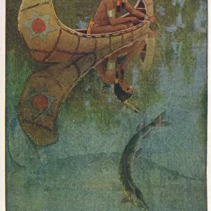
Champlain / Huron Indians
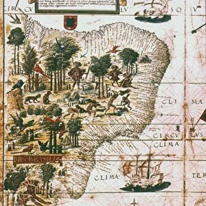
Samuel De Champlain, with help from the recently befriended Huron Indians, on the war path with the Iroquois
Mary Evans Picture Library makes available wonderful images created for people to enjoy over the centuries
Media ID 4328849
© Mary Evans Picture Library 2015 - https://copyrighthub.org/s0/hub1/creation/maryevans/MaryEvansPictureID/10172587
1609 Befriended Champlain Huron Indians Iroquois Path Recently Samuel
22"x18" Modern Frame
Introducing the captivating Champlain / Huron Indians Framed Print from Media Storehouse, a stunning addition to your home or office decor. This historical masterpiece, sourced from Mary Evans Prints Online, showcases an iconic moment in the exploration of the New World. Featuring the renowned explorer, Samuel de Champlain, and his new Huron Indian allies, this print captures the spirit of their joint venture on the war path against the Iroquois. The intricate details of the image bring the past to life, transporting you back in time. The Media Storehouse Framed Prints are not just beautiful works of art but also a testament to the rich history of North America. Each print is carefully framed in a sleek and contemporary design, ensuring a timeless appeal that complements any interior. Add this Champlain / Huron Indians Framed Print to your collection and be inspired by the courage, determination, and camaraderie between the explorer and the indigenous people as they forged a new path together.
20x16 Print in an MDF Wooden Frame with 180 gsm Satin Finish Paper. Glazed using shatter proof thin plexiglass. Frame thickness is 1 inch and depth 0.75 inch. Fluted cardboard backing held with clips. Supplied ready to hang with sawtooth hanger and rubber bumpers. Spot clean with a damp cloth. Packaged foam wrapped in a card.
Contemporary Framed and Mounted Prints - Professionally Made and Ready to Hang
Estimated Image Size (if not cropped) is 50.8cm x 45.7cm (20" x 18")
Estimated Product Size is 55.9cm x 45.7cm (22" x 18")
These are individually made so all sizes are approximate
Artwork printed orientated as per the preview above, with landscape (horizontal) orientation to match the source image.
FEATURES IN THESE COLLECTIONS
> Arts
> Artists
> C
> Samuel de Champlain
> North America
> Canada
> Related Images
EDITORS COMMENTS
In this evocative image from the annals of Canadian history, renowned explorer Samuel de Champlain (1567-1635) is depicted leading a war party of Huron Indians against their longstanding adversaries, the Iroquois, in the year 1609. Champlain, a Frenchman, had recently befriended the Huron people, who had welcomed him into their community and shared their knowledge of the land and its resources. The path before them winds through the dense forest, the trees casting long shadows as the sun begins to set. Champlain, dressed in his fur-trimmed explorer's coat, raises his hand in a gesture of encouragement to his Huron allies, who follow closely behind, their faces painted with the markings of war. The Iroquois, a formidable enemy, were known for their military prowess and had long been a threat to the Huron people. This historical event marked a significant moment in the relationship between the Europeans and the indigenous peoples of North America. Champlain's ability to forge alliances with the Huron and other native tribes was crucial to the success of French colonization in the region that would later become Canada. The image serves as a poignant reminder of the complex and often tumultuous history of interactions between European explorers and the indigenous peoples they encountered. The Huron-Iroquois War, as it came to be known, lasted for several years and resulted in significant losses for both sides. However, Champlain's alliance with the Huron proved to be a turning point in the conflict, ultimately leading to the weakening of Iroquois power in the region. This photograph, with its rich historical significance, offers a glimpse into the past and the intricate web of relationships that shaped the history of Canada.
MADE IN THE USA
Safe Shipping with 30 Day Money Back Guarantee
FREE PERSONALISATION*
We are proud to offer a range of customisation features including Personalised Captions, Color Filters and Picture Zoom Tools
SECURE PAYMENTS
We happily accept a wide range of payment options so you can pay for the things you need in the way that is most convenient for you
* Options may vary by product and licensing agreement. Zoomed Pictures can be adjusted in the Cart.