Canvas Print > Universal Images Group (UIG) > Universal Images Group > Satellite and Aerial > Planet Observer 5
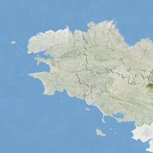
Canvas Print : Departement of Finistere, France, True Colour Satellite Image


![]()
Canvas Prints From Universal Images Group (UIG)
Departement of Finistere, France, True Colour Satellite Image
Satellite view of the departement of Finistere, France. This image was compiled from data acquired by LANDSAT 5 & 7 satellites
Universal Images Group (UIG) manages distribution for many leading specialist agencies worldwide
Media ID 9592569
© Planet Observer
Atlantic Ocean Brittany Coastline Finistere Geographical Border Island Shore Quimper Satellite View
20"x16" (51x41cm) Canvas Print
Discover the breathtaking beauty of Finistere, France, from a unique perspective with our Media Storehouse Canvas Print featuring a True Colour Satellite Image from Universal Images Group. This stunning depiction of the departement was compiled from data acquired by LANDSAT 5 & 7 satellites, offering a bird's-eye view of the intricate patterns of the land and the captivating blues of the Atlantic Ocean. Bring the wonders of space and earth into your home with this premium quality canvas print, perfect for adding a touch of wonder and inspiration to any room.
Delivered stretched and ready to hang our premium quality canvas prints are made from a polyester/cotton blend canvas and stretched over a 1.25" (32mm) kiln dried knot free wood stretcher bar. Packaged in a plastic bag and secured to a cardboard insert for safe transit.
Canvas Prints add colour, depth and texture to any space. Professionally Stretched Canvas over a hidden Wooden Box Frame and Ready to Hang
Estimated Product Size is 50.8cm x 40.6cm (20" x 16")
These are individually made so all sizes are approximate
Artwork printed orientated as per the preview above, with landscape (horizontal) orientation to match the source image.
EDITORS COMMENTS
This print showcases the breathtaking beauty of the Departement of Finistere in France. Taken from a true color satellite image, this mesmerizing view offers a unique perspective on the region's topography and natural wonders. The rugged coastline stretches along the vast Atlantic Ocean, creating a stunning contrast between land and water. The intricate details captured by LANDSAT 5 & 7 satellites allow us to explore every nook and cranny of this picturesque area. From the tranquil islands dotting the horizon to the dynamic shores that meet them, it is evident why Finistere is considered one of Brittany's most enchanting destinations. The vibrant colors displayed in this photograph highlight both its artistic value and its practical use for cartography purposes. With no people present in sight, we are left to marvel at nature's grandeur undisturbed. This horizontal composition invites viewers to immerse themselves in Europe's physical geography as they trace their fingers along geographical borders. Whether you're an avid traveler or simply appreciate fine photography, this print serves as a window into Finistere's allure. It captures not only its geographical features but also evokes feelings of wonder and wanderlust within those who gaze upon it
MADE IN THE USA
Safe Shipping with 30 Day Money Back Guarantee
FREE PERSONALISATION*
We are proud to offer a range of customisation features including Personalised Captions, Color Filters and Picture Zoom Tools
SECURE PAYMENTS
We happily accept a wide range of payment options so you can pay for the things you need in the way that is most convenient for you
* Options may vary by product and licensing agreement. Zoomed Pictures can be adjusted in the Basket.