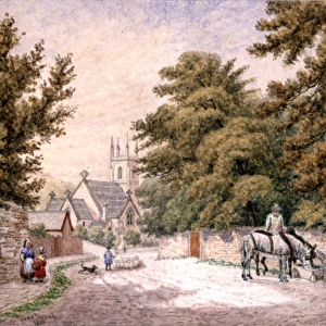
Canvas Print > Sheffield City Archives > Maps and Plans > Maps of Derbyshire
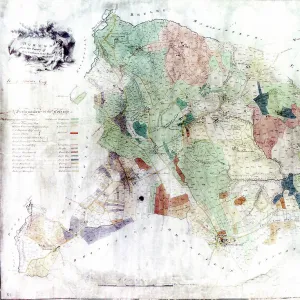
Canvas Print : Woodthorpe [Holmsfield], Dronfield, Derbyshire, 1741
![Woodthorpe [Holmsfield], Dronfield, Derbyshire, 1741](/image/716/14045377/14045377_600_600_7034_367_fill_0_818524cce32daffffe229efa0ca18e6f.jpg.webp "Woodthorpe [Holmsfield], Dronfield, Derbyshire, 1741")
![Woodthorpe [Holmsfield], Dronfield, Derbyshire, 1741](/p/716/woodthorpe-holmsfield-dronfield-derbyshire-14045377.jpg.webp "Woodthorpe [Holmsfield], Dronfield, Derbyshire, 1741")

![]()
Canvas Prints from Sheffield City Archives
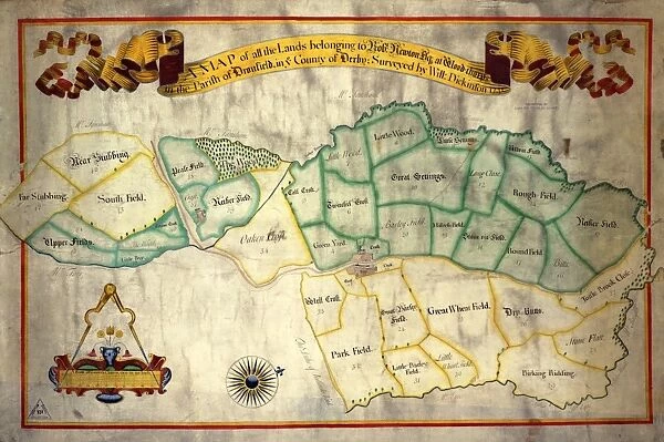
Woodthorpe [Holmsfield], Dronfield, Derbyshire, 1741
Full title: A map of all the lands belonging to Robert Newton esquire at Woodthorpe [Holmsfield] in the parish of Dronfield in the County of Derby, surveyed by William Dickinson, 1741.
Scale 5 chains : 3.2 inches.
Original at Sheffield Archives ref. arc00669
Sheffield City Archives and Local Studies Library has an unrivalled collection of images of Sheffield, England
Media ID 14045377
© Sheffield City Council
Derbyshire Dronfield Maps Sheffield Woodthorpe
30"x20" (76x51cm) Canvas Print
Bring history to life with our exquisite Canvas Print of "A map of all the lands belonging to Robert Newton esquire at Woodthorpe [Holmsfield] in the parish of Dronfield, Derbyshire, surveyed by William Dickinson, 1741" from Sheffield City Archives. This captivating piece, derived from the archives, offers a unique glimpse into the past. The intricate details of the map are beautifully rendered on premium canvas, adding depth and texture to your home or office decor. Transport yourself back in time with this stunning and authentic piece from Media Storehouse's collection of historical prints.
Delivered stretched and ready to hang our premium quality canvas prints are made from a polyester/cotton blend canvas and stretched over a 1.25" (32mm) kiln dried knot free wood stretcher bar. Packaged in a plastic bag and secured to a cardboard insert for safe transit.
Canvas Prints add colour, depth and texture to any space. Professionally Stretched Canvas over a hidden Wooden Box Frame and Ready to Hang
Estimated Product Size is 76.2cm x 50.8cm (30" x 20")
These are individually made so all sizes are approximate
Artwork printed orientated as per the preview above, with landscape (horizontal) orientation to match the source image.
EDITORS COMMENTS
This print showcases a historical map titled "Woodthorpe [Holmsfield], Dronfield, Derbyshire, 1741". The full title of this remarkable piece is "A map of all the lands belonging to Robert Newton esquire at Woodthorpe [Holmsfield] in the parish of Dronfield in the County of Derby, surveyed by William Dickinson, 1741". This meticulously crafted map was created with great precision and attention to detail by surveyor William Dickinson over two centuries ago. The photograph reveals a glimpse into the past, offering us an opportunity to explore the landscapes and boundaries that once defined this area. With a scale of 5 chains : 3.2 inches, every inch on this map represents an extensive stretch of land. It provides valuable insights into property ownership and land distribution during that era. Preserved within Sheffield Archives under reference arc00669, this historic artifact holds immense significance for researchers and history enthusiasts alike. It serves as a testament to our ancestors' dedication towards documenting their surroundings and understanding their place within it. As we gaze upon this print from Sheffield City Archives, let us appreciate the meticulous craftsmanship that went into creating such maps while acknowledging its cultural importance. This image invites us to delve deeper into Woodthorpe's rich history in Derbyshire and discover how it has evolved over time.
MADE IN THE USA
Safe Shipping with 30 Day Money Back Guarantee
FREE PERSONALISATION*
We are proud to offer a range of customisation features including Personalised Captions, Color Filters and Picture Zoom Tools
SECURE PAYMENTS
We happily accept a wide range of payment options so you can pay for the things you need in the way that is most convenient for you
* Options may vary by product and licensing agreement. Zoomed Pictures can be adjusted in the Cart.
![Map of Woodthorpe Hall Farm [Holmesfield] in the parish of Dronfield, County of Derby, 1736](/sq/716/map-woodthorpe-hall-farm-holmesfield-parish-18987347.jpg.webp)