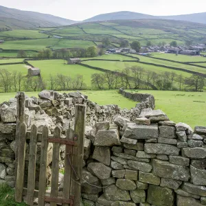
Canvas Print > Europe > United Kingdom > England > Yorkshire > Seamer
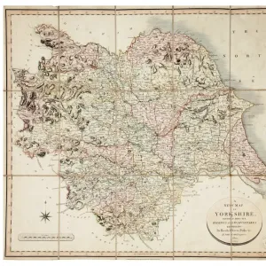
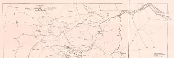
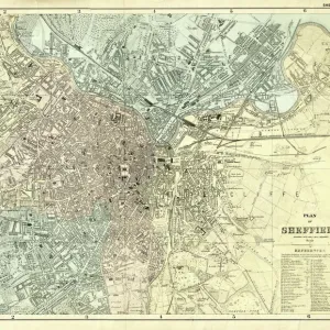
Canvas Print : Map of the South Yorkshire Coal Railway, and of the Canals and Railways communicating with the district, 1846


![]()
Canvas Prints from Sheffield City Archives
Map of the South Yorkshire Coal Railway, and of the Canals and Railways communicating with the district, 1846
By C. Bartholomew, Civil Engineer.Scale 2 miles : 1 inch.Original at Sheffield City Archives: BM/71
Sheffield City Archives and Local Studies Library has an unrivalled collection of images of Sheffield, England
Media ID 14046358
© Sheffield City Council
Canals Coal Industry Maps Plans Rail Railway Sheffield South Transport Yorkshire Colliery Grange Manchester Midland Seam Thorncliffe Wakefield
21"x7" (53x18cm) Canvas Print
Step back in time with our exquisite Canvas Print of the South Yorkshire Coal Railway and Communicating Canals and Railways Map from 1846. This captivating historical piece, originally created by renowned civil engineer C. Bartholomew, provides an intriguing glimpse into the industrial past of Sheffield. Printed on high-quality canvas, this detailed and vibrant representation of the map retains the original's charm while offering an elegant and timeless addition to your home or office decor. Bring history to life with Media Storehouse's Canvas Prints.
Delivered stretched and ready to hang our premium quality canvas prints are made from a polyester/cotton blend canvas and stretched over a 1.25" (32mm) kiln dried knot free wood stretcher bar. Packaged in a plastic bag and secured to a cardboard insert for safe transit.
Canvas Prints add colour, depth and texture to any space. Professionally Stretched Canvas over a hidden Wooden Box Frame and Ready to Hang
Estimated Product Size is 53.3cm x 17.8cm (21" x 7")
These are individually made so all sizes are approximate
Artwork printed orientated as per the preview above, with landscape (horizontal) orientation to match the source image.
FEATURES IN THESE COLLECTIONS
> Europe
> United Kingdom
> England
> Manchester
> Manchester
> Europe
> United Kingdom
> England
> South Yorkshire
> Related Images
> Europe
> United Kingdom
> England
> South Yorkshire
> Sheffield
> Europe
> United Kingdom
> England
> Yorkshire
> Grange
> Europe
> United Kingdom
> England
> Yorkshire
> Related Images
> Europe
> United Kingdom
> England
> Yorkshire
> Seamer
> Europe
> United Kingdom
> England
> Yorkshire
> Sheffield
> Europe
> United Kingdom
> England
> Yorkshire
> Silkstone
> Europe
> United Kingdom
> England
> Yorkshire
> Wakefield
> Maps and Charts
> Related Images
> Sheffield City Archives
> Maps and Plans
EDITORS COMMENTS
This print from Sheffield City Archives showcases the "Map of the South Yorkshire Coal Railway, and of the Canals and Railways communicating with the district" dating back to 1846. The detailed map was created by C. Bartholomew, a renowned Civil Engineer of that era. With a scale of 2 miles to 1 inch, this historical artifact provides invaluable insights into the transportation infrastructure during a time when coal mining played a significant role in South Yorkshire's industrial development. The map highlights various key locations such as Sheffield, Manchester, Wakefield, Silkstone Seam, Thorncliffe Colliery, Midland Grange, and more. It vividly illustrates how canals and railways interconnected within the region to facilitate efficient coal transport for industry purposes. This visual representation sheds light on how these vital transportation networks were intricately woven together to support economic growth. Preserved at Sheffield City Archives under reference BM/71, this original piece serves as an important resource for researchers and history enthusiasts alike. Its significance lies not only in its cartographic accuracy but also in capturing an essential aspect of South Yorkshire's rich industrial heritage
MADE IN THE USA
Safe Shipping with 30 Day Money Back Guarantee
FREE PERSONALISATION*
We are proud to offer a range of customisation features including Personalised Captions, Color Filters and Picture Zoom Tools
SECURE PAYMENTS
We happily accept a wide range of payment options so you can pay for the things you need in the way that is most convenient for you
* Options may vary by product and licensing agreement. Zoomed Pictures can be adjusted in the Cart.
![A map of the lands at and near Crooks [Crookes] part in Ecclesall and part in Nether Hallam, 1790](/sq/716/map-lands-near-crooks-crookes-ecclesall-nether-14049486.jpg.webp)