Canvas Print > Europe > Italy > Maps
Canvas Print : Toscanellis world map, 1474


![]()
Canvas Prints From Science Photo Library
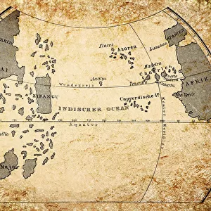
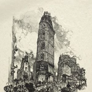
Toscanellis world map, 1474
Toscanellis world map. This map was drawn by the Italian mathematician and astronomer Paolo Toscanelli (1397-1482) in 1474. It was used by Christopher Columbus for his first voyage to find a westward route to Asia. The map led him to falsely believe he had found a route to Asia, rather than discovering North America. Engraving by Konrad Kretschmer, Germany, circa 1850
Science Photo Library features Science and Medical images including photos and illustrations
Media ID 6322545
© CCI ARCHIVES/SCIENCE PHOTO LIBRARY
15th Century Cartography Christopher Columbus Drawing Hexagonal Incomplete Incorrect World Map 1474 Mono Chrome
20"x16" (51x41cm) Canvas Print
"Step back in time with our exquisite Canvas Print of Paolo Toscanelli's World Map from Science Photo Library, dated 1474. This beautiful reproduction showcases the intricate detail and historical significance of one of the most influential maps in cartographic history. With vibrant colors and a high-quality finish, our Canvas Prints bring the past to life in your home or office, making for a captivating conversation starter. Travel back to the Renaissance era and adorn your space with this stunning work of cartographic art."
Delivered stretched and ready to hang our premium quality canvas prints are made from a polyester/cotton blend canvas and stretched over a 1.25" (32mm) kiln dried knot free wood stretcher bar. Packaged in a plastic bag and secured to a cardboard insert for safe transit.
Canvas Prints add colour, depth and texture to any space. Professionally Stretched Canvas over a hidden Wooden Box Frame and Ready to Hang
Estimated Product Size is 50.8cm x 40.6cm (20" x 16")
These are individually made so all sizes are approximate
Artwork printed orientated as per the preview above, with landscape (horizontal) orientation to match the source image.
FEATURES IN THESE COLLECTIONS
> Europe
> Germany
> Related Images
> Maps and Charts
> Early Maps
> Maps and Charts
> Italy
> Maps and Charts
> Related Images
EDITORS COMMENTS
This print showcases Toscanelli's world map, a significant historical artifact that shaped the course of exploration in the 15th century. Created by Italian mathematician and astronomer Paolo Toscanelli in 1474, this intricate illustration holds immense geographical importance. Used by Christopher Columbus during his inaugural voyage to discover a westward route to Asia, this map ultimately led him astray. The hexagonal design beautifully captures the essence of cartography during that era, with Europe and Asia taking center stage. However, as history would reveal, Columbus mistakenly believed he had reached his intended destination when he stumbled upon North America instead. This incomplete representation of the world inadvertently altered our understanding of geography at the time. Engraved by Konrad Kretschmer in Germany around 1850, this monochrome artwork breathes life into an erroneous depiction that once held great significance. It serves as a reminder of how even renowned explorers like Christopher Columbus could be misled by inaccurate maps. With its rich historical context and artistic allure, this print from Science Photo Library offers viewers a glimpse into an era where cartographic knowledge was still evolving. It stands as a testament to human curiosity and reminds us that even mistakes can lead to remarkable discoveries.
MADE IN THE USA
Safe Shipping with 30 Day Money Back Guarantee
FREE PERSONALISATION*
We are proud to offer a range of customisation features including Personalised Captions, Color Filters and Picture Zoom Tools
SECURE PAYMENTS
We happily accept a wide range of payment options so you can pay for the things you need in the way that is most convenient for you
* Options may vary by product and licensing agreement. Zoomed Pictures can be adjusted in the Basket.