Canvas Print > Europe > Andorra > Maps
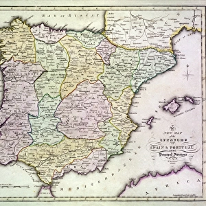
Canvas Print : Traditional provinces of Spain


![]()
Canvas Prints From North Wind
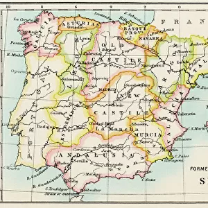
Traditional provinces of Spain
Map of the former provinces of Spain.
Printed color lithograph of a 19th-century illustration
North Wind Picture Archives brings history to life with stock images and hand-colored illustrations
Media ID 5882211
© North Wind Picture Archives
Europe European Portugal Spain Spanish Andorra Aragon Asturia Basque Castile Estremadura Galicia Iberia Iberian Peninsula Leon Murcia Navarra
20"x16" (51x41cm) Canvas Print
Introducing the stunning Media Storehouse Canvas Prints featuring the "Traditional Provinces of Spain" from North Wind Picture Archives. This captivating print showcases a beautifully detailed, color lithograph map of the former provinces of Spain from the 19th century. Delve into the rich history and culture of Spain with this intricately designed piece of art. The high-quality canvas print brings the classic illustration to life with vibrant colors and a textured finish that adds depth and dimension. Elevate your home or office décor with this unique and educational addition. Experience the charm of Spain's diverse regions with every glance at this exquisite work of art.
Delivered stretched and ready to hang our premium quality canvas prints are made from a polyester/cotton blend canvas and stretched over a 1.25" (32mm) kiln dried knot free wood stretcher bar. Packaged in a plastic bag and secured to a cardboard insert for safe transit.
Canvas Prints add colour, depth and texture to any space. Professionally Stretched Canvas over a hidden Wooden Box Frame and Ready to Hang
Estimated Product Size is 50.8cm x 40.6cm (20" x 16")
These are individually made so all sizes are approximate
Artwork printed orientated as per the preview above, with landscape (horizontal) orientation to match the source image.
FEATURES IN THESE COLLECTIONS
> Europe
> Andorra
> Related Images
> Europe
> Portugal
> Related Images
> Europe
> Spain
> Related Images
> North Wind Picture Archives
> Maps
EDITORS COMMENTS
This vintage print showcases the rich heritage and history of Spain through a beautifully detailed map of its traditional provinces. The printed color lithograph, dating back to the 19th century, offers a glimpse into the diverse regions that make up this European country. The map highlights each province with intricate illustrations, capturing the essence of their unique cultural identities. From Basque Country in the north to Andalusia in the south, from Catalonia in the east to Galicia in the west, these provinces have played significant roles throughout Spanish history. As you explore this artwork, you can trace your finger along Castile's vast plains or marvel at Valencia's stunning coastline. Discover Leon's medieval charm or admire Aragon's architectural wonders. Each province tells its own story and contributes to Spain's vibrant tapestry. Beyond Spain’s borders lie neighboring territories like Portugal and Andorra on the Iberian Peninsula. This print serves as a reminder of their close ties with Spain and how they have influenced one another over time. Whether you are an art enthusiast or a history buff, this vintage illustration is sure to captivate your imagination and transport you back in time. It is not just a mere depiction of geographical boundaries but also an artistic representation of Spain’s rich cultural legacy that continues to shape its present-day identity.
MADE IN THE USA
Safe Shipping with 30 Day Money Back Guarantee
FREE PERSONALISATION*
We are proud to offer a range of customisation features including Personalised Captions, Color Filters and Picture Zoom Tools
SECURE PAYMENTS
We happily accept a wide range of payment options so you can pay for the things you need in the way that is most convenient for you
* Options may vary by product and licensing agreement. Zoomed Pictures can be adjusted in the Basket.