Canvas Print > Historic > Ancient civilizations > Ancient Greece > Greek history
Canvas Print : EXPL2A-00061


![]()
Canvas Prints from North Wind
EXPL2A-00061
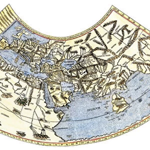
Ptolemys world map, circa 150 AD, from the edition of 1472.
Color halftone reproduction of the first printed edition of 1472
North Wind Picture Archives brings history to life with stock images and hand-colored illustrations
Media ID 5880241
© North Wind Picture Archives
1400s 15th Century Adventure Africa Ancient Asia Atlantic Ocean Cartography Chart Discover Europe Exploration Explore Flat Earth Greece Greek Indian Ocean Maritime Mediterranean Mediterranean Sea Navigation Ocean Travel Wind World World Map 1472 Claudius Ptolemaeus Ptolemy
20"x16" (51x41cm) Canvas Print
Bring history to life with Media Storehouse's Canvas Prints. This captivating piece features the iconic Ptolemaic World Map from North Wind Picture Archives, circa 150 AD. Reproduced from the first printed edition of 1472, this color halftone canvas print showcases the intricate details and rich history of one of the oldest surviving maps. Transport yourself back in time and add an element of ancient wisdom to your decor. Order your Media Storehouse Canvas Print of EXPL2A-00061 today.
Delivered stretched and ready to hang our premium quality canvas prints are made from a polyester/cotton blend canvas and stretched over a 1.25" (32mm) kiln dried knot free wood stretcher bar. Packaged in a plastic bag and secured to a cardboard insert for safe transit.
Canvas Prints add colour, depth and texture to any space. Professionally Stretched Canvas over a hidden Wooden Box Frame and Ready to Hang
Estimated Product Size is 50.8cm x 40.6cm (20" x 16")
These are individually made so all sizes are approximate
Artwork printed orientated as per the preview above, with landscape (horizontal) orientation to match the source image.
FEATURES IN THESE COLLECTIONS
> Africa
> Related Images
> Arts
> Artists
> O
> Oceanic Oceanic
> Asia
> Related Images
> Europe
> Greece
> Related Images
> Historic
> Ancient civilizations
> Ancient Greece
> Greek history
> Maps and Charts
> Early Maps
> Maps and Charts
> Flat Earth
> North Wind Picture Archives
> Exploration
> North Wind Picture Archives
> Maps
EDITORS COMMENTS
This print takes us back in time to the ancient world of Ptolemy, circa 150 AD. The image showcases a color halftone reproduction of the first printed edition from 1472, allowing us to marvel at the intricate details and historical significance it holds. The map itself is a testament to human curiosity and exploration, depicting Ptolemy's understanding of the world during that era. With its vintage charm and artistic flair, this print transports us to an age where wind-powered ships sailed across vast oceans in search of new lands and adventures. As we gaze upon this remarkable illustration, we can't help but imagine the brave sailors who relied on these maps for navigation as they embarked on perilous journeys through uncharted waters. The Atlantic Ocean stretches out before them while the Mediterranean Sea acts as a gateway between Europe, Africa, and Asia. This piece serves as a reminder of how far our knowledge has come since those early days of cartography. It symbolizes not only our thirst for discovery but also our ability to preserve history through art. Let this photograph transport you back in time and ignite your own sense of wanderlust as you explore Ptolemy's world map from 1472 – an extraordinary artifact that continues to captivate even centuries later.
MADE IN THE USA
Safe Shipping with 30 Day Money Back Guarantee
FREE PERSONALISATION*
We are proud to offer a range of customisation features including Personalised Captions, Color Filters and Picture Zoom Tools
SECURE PAYMENTS
We happily accept a wide range of payment options so you can pay for the things you need in the way that is most convenient for you
* Options may vary by product and licensing agreement. Zoomed Pictures can be adjusted in the Cart.