Canvas Print > Europe > United Kingdom > England > Huntingdonshire
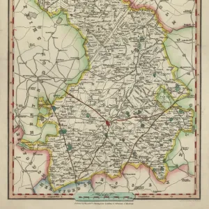
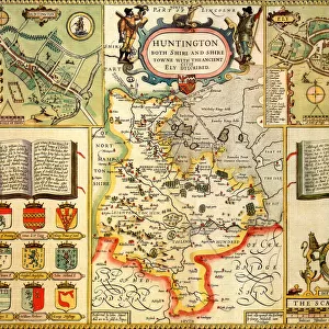
Canvas Print : Map / Huntingdonshire 1810


![]()
Canvas Prints from Mary Evans Picture Library
Map / Huntingdonshire 1810
Map of Huntingdonshire
Mary Evans Picture Library makes available wonderful images created for people to enjoy over the centuries
Media ID 573980
© Mary Evans Picture Library 2015 - https://copyrighthub.org/s0/hub1/creation/maryevans/MaryEvansPictureID/10009512
20"x16" (51x41cm) Canvas Print
Introducing the captivating "Map / Huntingdonshire 1810" from the Media Storehouse collection of Canvas Prints, brought to you by Mary Evans Picture Library from Mary Evans Prints Online. This exquisite piece of historical cartography transports you back in time, showcasing intricate details of Huntingdonshire as it appeared over 200 years ago. The vintage map, adorned with meticulous lines and annotations, is a testament to the rich history and geography of the region. Each canvas print is meticulously crafted with premium materials, ensuring vibrant colors and stunning detail that bring this piece to life in your home or office. Elevate your decor with a touch of history and timeless beauty - order your "Map / Huntingdonshire 1810" Canvas Print today.
Delivered stretched and ready to hang our premium quality canvas prints are made from a polyester/cotton blend canvas and stretched over a 1.25" (32mm) kiln dried knot free wood stretcher bar. Packaged in a plastic bag and secured to a cardboard insert for safe transit.
Canvas Prints add colour, depth and texture to any space. Professionally Stretched Canvas over a hidden Wooden Box Frame and Ready to Hang
Estimated Product Size is 50.8cm x 40.6cm (20" x 16")
These are individually made so all sizes are approximate
Artwork printed orientated as per the preview above, with landscape (horizontal) orientation to match the source image.
FEATURES IN THESE COLLECTIONS
> Europe
> United Kingdom
> England
> Huntingdonshire
> Europe
> United Kingdom
> England
> Maps
> Europe
> United Kingdom
> England
> Posters
> Europe
> United Kingdom
> England
> Related Images
> Maps and Charts
> Early Maps
> Maps and Charts
> Related Images
EDITORS COMMENTS
This stunning print captures a piece of history with the Map of Huntingdonshire from 1810. The intricate details and delicate lines on this map provide a glimpse into the past, showcasing the geography and boundaries of Huntingdonshire in England during that time period.
As we study this historical map, we can imagine what life was like in Huntingdonshire over two centuries ago. From small villages to sprawling countryside, this map gives us insight into how the land was divided and utilized by its inhabitants. It serves as a valuable resource for historians and enthusiasts alike who are interested in exploring the evolution of this region.
The craftsmanship and artistry evident in this map remind us of a time when cartography was both practical and beautiful. Each stroke of ink represents hours of meticulous work by skilled hands, creating a visual masterpiece that stands the test of time.
Whether you have personal ties to Huntingdonshire or simply appreciate historical artifacts, this Map of Huntingdonshire from 1810 is sure to captivate your imagination. Display it proudly in your home or office as a conversation piece that sparks curiosity about our shared past.
MADE IN THE USA
Safe Shipping with 30 Day Money Back Guarantee
FREE PERSONALISATION*
We are proud to offer a range of customisation features including Personalised Captions, Color Filters and Picture Zoom Tools
SECURE PAYMENTS
We happily accept a wide range of payment options so you can pay for the things you need in the way that is most convenient for you
* Options may vary by product and licensing agreement. Zoomed Pictures can be adjusted in the Cart.