Canvas Print > Europe > United Kingdom > England > London > Sights > Harrods
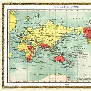
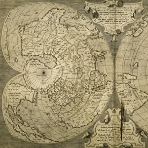
Canvas Print : Harrods advert world map, c. 1909


![]()
Canvas Prints From Mary Evans Picture Library
Harrods advert world map, c. 1909
A world map, advertising Harrods department store, touted here as the supply centre of the British Empire. Land belonging to the British Empire is marked in red, with the flagship London store appearing in a vignette. Date: 1909
Mary Evans Picture Library makes available wonderful images created for people to enjoy over the centuries
Media ID 14123793
© Mary Evans Picture Library
Department Harrods Knightsbridge Store
20"x16" (51x41cm) Canvas Print
Step back in time with our exquisite Harrods Advert World Map Canvas Print from Media Storehouse. This captivating vintage map, hailing from 1909, showcases Harrods Department Store as the epicenter of the British Empire. Richly detailed, this world map, sourced from Mary Evans Prints Online, highlights the reach and influence of the empire with red markings indicating territories under its rule. Bring a touch of history and elegance to your home or office with this unique and intriguing canvas print.
Delivered stretched and ready to hang our premium quality canvas prints are made from a polyester/cotton blend canvas and stretched over a 1.25" (32mm) kiln dried knot free wood stretcher bar. Packaged in a plastic bag and secured to a cardboard insert for safe transit.
Canvas Prints add colour, depth and texture to any space. Professionally Stretched Canvas over a hidden Wooden Box Frame and Ready to Hang
Estimated Image Size (if not cropped) is 50.8cm x 36.8cm (20" x 14.5")
Estimated Product Size is 50.8cm x 40.6cm (20" x 16")
These are individually made so all sizes are approximate
Artwork printed orientated as per the preview above, with landscape (horizontal) orientation to match the source image.
FEATURES IN THESE COLLECTIONS
> Europe
> France
> Canton
> Landes
> Europe
> United Kingdom
> England
> London
> Museums
> British Library
> Europe
> United Kingdom
> England
> London
> Sights
> Harrods
> Maps and Charts
> British Empire Maps
> Maps and Charts
> Early Maps
> Maps and Charts
> Related Images
> Maps and Charts
> World
EDITORS COMMENTS
This world map, hailing from the year 1909, serves as an intriguing snapshot of Harrods Department Store's ambitious marketing strategy during the Edwardian era. The map, adorned with the Harrods logo and the tagline "Harrods, the Supply Centre of the British Empire," presents a vivid representation of the vast territories under British rule, denoted by the distinctive red hue. At the heart of this global network lies the flagship Harrods store, located in Knightsbridge, London, depicted in a charming vignette. The map not only underscores Harrods' commitment to catering to the needs of the British Empire but also showcases the extent of its reach and influence. The intricate details on this map are a testament to the meticulous craftsmanship of the time. From the labyrinthine railways and shipping routes to the precise demarcation of colonial territories, each element contributes to the overall allure of this historical artifact. As we delve deeper into the map, we are transported back to an era of imperial grandeur and commercial prowess. The Harrods world map of 1909 stands as a tangible reminder of the British Empire's global dominance and the role that Harrods played in supplying its far-flung territories. This enchanting piece of advertising history not only offers a glimpse into the past but also serves as a fascinating study of the intricate relationship between commerce, imperialism, and cartography during the early 20th century.
MADE IN THE USA
Safe Shipping with 30 Day Money Back Guarantee
FREE PERSONALISATION*
We are proud to offer a range of customisation features including Personalised Captions, Color Filters and Picture Zoom Tools
SECURE PAYMENTS
We happily accept a wide range of payment options so you can pay for the things you need in the way that is most convenient for you
* Options may vary by product and licensing agreement. Zoomed Pictures can be adjusted in the Basket.