Canvas Print > Arts > Artists > H > Jodocus Hondius
Canvas Print : Old County Map of Kyle and Mid Ayrshire 1654 by johan Blaeu from the Atlas Novus


![]()
Canvas Prints From MapSeeker
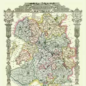
Old County Map of Kyle and Mid Ayrshire 1654 by johan Blaeu from the Atlas Novus
This detailed and most attractive reproduction map of Kyle and Mid Ayrshire has been carefully art worked from a scan of an antique original. A map of the historic Scottish district of Kyle, bordering Carrick, Galloway and Clydsdale. Based on the work of the famous Scottish surveyor Timothy Pont. Map is very detailed, with the inclusion of rivers, lochs, mountains, cities, villages and castles. With decorative title and scale cartouches, the former surrounded by regional figures and their livestock. Dedication is in a fantastically detailed cartouche, the Scottish rampant lion crest flanked by two further lions and with the motto conscia virtus. Some of the decoration has been picked out in gold. Latin text to verso. From Blaeus Atlas Novus. The famous firm of Dutch cartographers and publishers was established in the late 16th century by Willem Janszoon Blaeu in Amsterdam. Blaeu was a maker of globes and scientific instruments and purchased some of his early map plates from Jodocus Hondius. From this small beginning was to emerge one of the largest and most prolific map publishing houses of the seventeenth century
Welcome to the Mapseeker Image library and enter an historic gateway to one of the largest on-line collections of Historic Maps, Nostalgic Views, Vista's and Panorama's from a World gone by.
Media ID 20347830
Blaeu Blaeu Family Blaue Map County Map County Map Of Scotland Historic Map Johan Blaeu Johan Blaeu Map Old Blaue Map Old County Map Old Scottish County Map Scottish County Map Kyle
30"x20" (76x51cm) Canvas Print
Introducing the Old County Map of Kyle and Mid Ayrshire 1654 by Johan Blaeu from the Atlas Novus, now available as a stunning Canvas Print from Media Storehouse. This exquisite reproduction map transports you back in time, with intricate details and vibrant colors that bring the history of Kyle and Mid Ayrshire to life. Carefully art worked from a high-resolution scan of an original antique map, each Canvas Print is meticulously crafted to preserve the authenticity and beauty of this precious historical artifact. Add a touch of timeless charm to your home or office décor with this eye-catching and conversation-starting piece. Order your Old County Map of Kyle and Mid Ayrshire 1654 Canvas Print today and let the stories of the past unfold before your very eyes.
Delivered stretched and ready to hang our premium quality canvas prints are made from a polyester/cotton blend canvas and stretched over a 1.25" (32mm) kiln dried knot free wood stretcher bar. Packaged in a plastic bag and secured to a cardboard insert for safe transit.
Canvas Prints add colour, depth and texture to any space. Professionally Stretched Canvas over a hidden Wooden Box Frame and Ready to Hang
Estimated Product Size is 76.2cm x 50.8cm (30" x 20")
These are individually made so all sizes are approximate
Artwork printed orientated as per the preview above, with landscape (horizontal) orientation to match the source image.
FEATURES IN THESE COLLECTIONS
> Animals
> Mammals
> Mountain Lion
> Arts
> Artists
> B
> Willem Blaeu
> Arts
> Artists
> H
> Jodocus Hondius
> Arts
> Photorealistic artworks
> Detailed art pieces
> Masterful detailing in art
> Europe
> United Kingdom
> Scotland
> Ayrshire
> Europe
> United Kingdom
> Scotland
> Castles
> Europe
> United Kingdom
> Scotland
> Dumfries and Galloway
> Related Images
> Europe
> United Kingdom
> Scotland
> Maps
> Europe
> United Kingdom
> Scotland
> Rivers
> Europe
> United Kingdom
> Scotland
> Scottish Borders
> Related Images
> Maps and Charts
> Willem Janszoon Blaeu
EDITORS COMMENTS
This beautifully crafted reproduction map of Kyle and Mid Ayrshire takes us back in time to the year 1654. Created by renowned cartographer Johan Blaeu, this print is a true work of art that captures the essence of this historic Scottish district. Based on the meticulous surveys conducted by Timothy Pont, this highly detailed map showcases the rivers, lochs, mountains, cities, villages, and castles that define Kyle's landscape. The inclusion of decorative title and scale cartouches adds an elegant touch to the overall design. These ornate elements are adorned with regional figures and their livestock, bringing life to the map. One cannot help but be captivated by the dedication cartouche featured on this print. With intricate details highlighted in gold, it proudly displays Scotland's rampant lion crest flanked by two additional lions. Accompanied by the motto "conscia virtus" meaning conscious virtue or bravery knows itself well. Originating from Blaeu's Atlas Novus collection, which was published by his esteemed Dutch firm established in Amsterdam during the late 16th century. This company would go on to become one of history's largest and most prolific map publishing houses throughout the seventeenth century. Whether you're a history enthusiast or simply appreciate fine craftsmanship, this reproduction map offers a glimpse into Scotland's past while showcasing Johan Blaeu's remarkable talent as a cartographer.
MADE IN THE USA
Safe Shipping with 30 Day Money Back Guarantee
FREE PERSONALISATION*
We are proud to offer a range of customisation features including Personalised Captions, Color Filters and Picture Zoom Tools
SECURE PAYMENTS
We happily accept a wide range of payment options so you can pay for the things you need in the way that is most convenient for you
* Options may vary by product and licensing agreement. Zoomed Pictures can be adjusted in the Basket.