Canvas Print > Popular Themes > Politics
Canvas Print : Childrens Political British Isles Map


![]()
Canvas Prints From Map Marketing
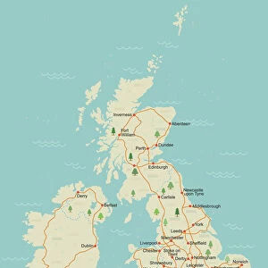
Childrens Political British Isles Map
The British Isles Political map designed for school children was created using Universal Transverse Mercator projection. This political student map clearly marks the counties and unitary authorities in different colours with cities and towns displayed in six population bands. The legend also includes a graphical representation of the five largest conurbations by population compared to the five largest counties by area
Media ID 19950391
© Map Marketing Ltd
Capitals Counties Population Student
20"x16" (51x41cm) Canvas Print
Delivered stretched and ready to hang our premium quality canvas prints are made from a polyester/cotton blend canvas and stretched over a 1.25" (32mm) kiln dried knot free wood stretcher bar. Packaged in a plastic bag and secured to a cardboard insert for safe transit.
Canvas Prints add colour, depth and texture to any space. Professionally Stretched Canvas over a hidden Wooden Box Frame and Ready to Hang
Estimated Product Size is 40.6cm x 50.8cm (16" x 20")
These are individually made so all sizes are approximate
Artwork printed orientated as per the preview above, with portrait (vertical) orientation to match the source image.
FEATURES IN THESE COLLECTIONS
> Maps and Charts
> Related Images
MADE IN THE USA
Safe Shipping with 30 Day Money Back Guarantee
FREE PERSONALISATION*
We are proud to offer a range of customisation features including Personalised Captions, Color Filters and Picture Zoom Tools
SECURE PAYMENTS
We happily accept a wide range of payment options so you can pay for the things you need in the way that is most convenient for you
* Options may vary by product and licensing agreement. Zoomed Pictures can be adjusted in the Basket.