Canvas Print > Europe > United Kingdom > Maps
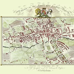
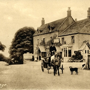
Canvas Print : Map, Griffiths new historical description of Cheltenham and its vicinity, 19th


![]()
Canvas Prints From Liszt Collection
Map, Griffiths new historical description of Cheltenham and its vicinity, 19th
Map, Griffiths new historical description of Cheltenham and its vicinity, 19th century engraving, UK
Liszt Collection of nineteenth-century engravings and images to browse and enjoy
Media ID 12805289
© Quint Lox Limited
20"x16" (51x41cm) Canvas Print
"Step back in time with our exquisite Canvas Prints from the Media Storehouse collection. This stunning piece features a captivating 19th century engraving of "Griffiths new historical description of Cheltenham and its vicinity" from the Liszt Collection. The intricate details of the map, with its charming depictions of Cheltenham and its surroundings, are brought to life in vibrant colors on high-quality canvas. Hang this beautiful work of art on your wall and add a touch of historical charm to any room in your home or office. Each print is carefully crafted using premium materials and techniques to ensure lasting brilliance. Order yours today and let history come alive in your space."
Delivered stretched and ready to hang our premium quality canvas prints are made from a polyester/cotton blend canvas and stretched over a 1.25" (32mm) kiln dried knot free wood stretcher bar. Packaged in a plastic bag and secured to a cardboard insert for safe transit.
Canvas Prints add colour, depth and texture to any space. Professionally Stretched Canvas over a hidden Wooden Box Frame and Ready to Hang
Estimated Product Size is 50.8cm x 40.6cm (20" x 16")
These are individually made so all sizes are approximate
Artwork printed orientated as per the preview above, with landscape (horizontal) orientation to match the source image.
FEATURES IN THESE COLLECTIONS
> Europe
> United Kingdom
> Maps
> Maps and Charts
> Early Maps
> Maps and Charts
> Related Images
EDITORS COMMENTS
This print showcases a remarkable piece of history - the "Map, Griffiths new historical description of Cheltenham and its vicinity, 19th century engraving" from the Liszt Collection. Steeped in nostalgia, this exquisite map takes us back to a bygone era in the United Kingdom. The intricate details and fine craftsmanship of this 19th-century engraving are truly awe-inspiring. Every street, building, and landmark is meticulously depicted, offering an invaluable glimpse into Cheltenham's past. As we gaze upon this artwork, we can almost imagine ourselves walking through the charming streets of olden-day Cheltenham. Beyond its aesthetic beauty lies a wealth of historical significance. This map serves as both an educational resource and a testament to the evolution of urban landscapes over time. It allows us to trace the growth and development of Cheltenham throughout centuries gone by. Moreover, it sparks curiosity about how life must have been during that period - bustling markets filled with merchants selling their wares or horse-drawn carriages traversing cobblestone streets. The map invites us to explore further into Cheltenham's rich heritage and discover tales waiting to be unraveled. As we admire this stunning print from the Liszt Collection, let us appreciate not only its artistic value but also its ability to transport us back in time. It reminds us that beneath our modern surroundings lie layers upon layers of stories just waiting to be discovered.
MADE IN THE USA
Safe Shipping with 30 Day Money Back Guarantee
FREE PERSONALISATION*
We are proud to offer a range of customisation features including Personalised Captions, Color Filters and Picture Zoom Tools
SECURE PAYMENTS
We happily accept a wide range of payment options so you can pay for the things you need in the way that is most convenient for you
* Options may vary by product and licensing agreement. Zoomed Pictures can be adjusted in the Basket.