
Canvas Print > Liszt Collection > Engravings
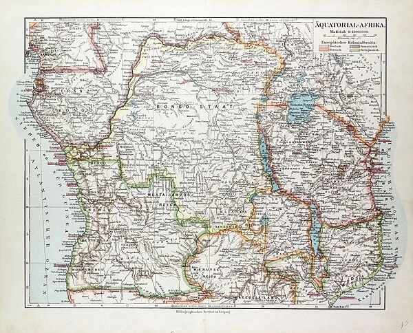
Canvas Print : Map of Equatorial Africa, the Republic of Mozambique, the Republic of Angola, Uganda


![]()
Canvas Prints from Liszt Collection
Map of Equatorial Africa, the Republic of Mozambique, the Republic of Angola, Uganda
Map of Equatorial Africa, the Republic of Mozambique, the Republic of Angola, Uganda, Kenya, 1899
Liszt Collection of nineteenth-century engravings and images to browse and enjoy
Media ID 12974405
© Quint Lox Limited
1899 Africa Kenya Plan Uganda Equatorial Africa
20"x16" (51x41cm) Canvas Print
Bring the rich history of Africa into your home with our stunning Canvas Prints from Media Storehouse. This captivating map, hailing from the Liszt Collection, dates back to 1899 and showcases Equatorial Africa, featuring the Republics of Mozambique and Angola, as well as Uganda, Kenya. The intricate details of the map are beautifully rendered in high-definition on our premium canvas, ensuring a vibrant and lifelike representation. Perfect for those who appreciate the art of cartography and the historical significance of this region, this Canvas Print is a unique and thoughtful addition to any space.
Delivered stretched and ready to hang our premium quality canvas prints are made from a polyester/cotton blend canvas and stretched over a 1.25" (32mm) kiln dried knot free wood stretcher bar. Packaged in a plastic bag and secured to a cardboard insert for safe transit.
Canvas Prints add colour, depth and texture to any space. Professionally Stretched Canvas over a hidden Wooden Box Frame and Ready to Hang
Estimated Product Size is 50.8cm x 40.6cm (20" x 16")
These are individually made so all sizes are approximate
Artwork printed orientated as per the preview above, with landscape (horizontal) orientation to match the source image.
EDITORS COMMENTS
This vintage print titled "Map of Equatorial Africa, the Republic of Mozambique, the Republic of Angola, Uganda" takes us on a journey back to the late 19th century. With its intricate engravement and illustrative technique, it showcases the rich history and cultural diversity of this region. The map depicts an expansive area that includes Equatorial Africa, Mozambique, Angola, Uganda, and Kenya. Its Victorian-style design adds a touch of elegance and nostalgia to this historical piece. The attention to detail is evident in every line and curve engraved with precision. As we gaze upon this artwork from the Liszt Collection, we are transported to a time when exploration was at its peak. It serves as a reminder of how far our understanding of geography has come since then. The retro styling evokes a sense of wonderment about what life was like during that era. This print not only captures geographical information but also tells a story about colonialism and European influence in Africa during the 19th century. Whether you're an art enthusiast or history buff, this print offers both aesthetic pleasure and educational value. It's an exquisite addition to any collection or display space for those who appreciate timeless beauty intertwined with historical significance.
MADE IN THE USA
Safe Shipping with 30 Day Money Back Guarantee
FREE PERSONALISATION*
We are proud to offer a range of customisation features including Personalised Captions, Color Filters and Picture Zoom Tools
SECURE PAYMENTS
We happily accept a wide range of payment options so you can pay for the things you need in the way that is most convenient for you
* Options may vary by product and licensing agreement. Zoomed Pictures can be adjusted in the Cart.