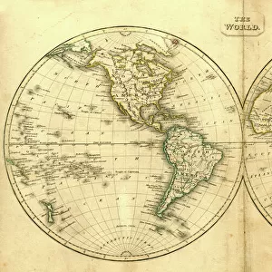
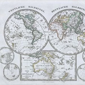
Canvas Print : 1799, Cruttwell Map of the World in Hemispheres, topography, cartography, geography


![]()
Canvas Prints From Liszt Collection
1799, Cruttwell Map of the World in Hemispheres, topography, cartography, geography
1799, Cruttwell Map of the World in Hemispheres
Liszt Collection of nineteenth-century engravings and images to browse and enjoy
Media ID 14006946
© Artokoloro Quint Lox Limited
1799 Antique Map Latitude Longitude Mappa Mundi Old Antique Plan Old Antique View Ols Antique Map Rare Old Maps Topo
30"x20" (76x51cm) Canvas Print
Step back in time with our exquisite Canvas Print of the 1799 Cruttwell Map of the World in Hemispheres from the renowned Liszt Collection. This captivating piece of cartographic history showcases intricate topography and geographical details of the world as it was known over two centuries ago. Each Canvas Print is meticulously crafted using high-quality materials and vibrant colors, ensuring a stunning visual representation of this rare and valuable map. Add an air of sophistication and historical charm to your home or office décor with this unique and captivating Canvas Print.
Delivered stretched and ready to hang our premium quality canvas prints are made from a polyester/cotton blend canvas and stretched over a 1.25" (32mm) kiln dried knot free wood stretcher bar. Packaged in a plastic bag and secured to a cardboard insert for safe transit.
Canvas Prints add colour, depth and texture to any space. Professionally Stretched Canvas over a hidden Wooden Box Frame and Ready to Hang
Estimated Product Size is 76.2cm x 50.8cm (30" x 20")
These are individually made so all sizes are approximate
Artwork printed orientated as per the preview above, with landscape (horizontal) orientation to match the source image.
EDITORS COMMENTS
This print showcases the remarkable "1799, Cruttwell Map of the World in Hemispheres" a true masterpiece of cartography and geography. With its intricate topography and detailed illustrations, this vintage map takes us on a journey through time, offering a glimpse into the ancient world. The carefully crafted lines and grids denote latitude and longitude, providing an accurate representation of our planet's diverse regions. Every inch of this historic map is filled with artistic flair, making it not only a valuable tool for navigation but also a decorative piece that adds charm to any space. As we gaze upon this aged treasure, we are transported back to an era when exploration and discovery were at their peak. The faded colors evoke nostalgia while reminding us of the rich history that lies within these pages. This rare old map serves as a testament to human curiosity and ingenuity. It reminds us of how far we have come in understanding our world while honoring those who paved the way for future generations' geographical knowledge. Whether displayed in an office or home setting, this antique print sparks conversations about our planet's past and inspires dreams of new adventures yet to be embarked upon. It is more than just paper; it is an artful depiction of Earth's wonders that continues to captivate minds even centuries after its creation.
MADE IN THE USA
Safe Shipping with 30 Day Money Back Guarantee
FREE PERSONALISATION*
We are proud to offer a range of customisation features including Personalised Captions, Color Filters and Picture Zoom Tools
SECURE PAYMENTS
We happily accept a wide range of payment options so you can pay for the things you need in the way that is most convenient for you
* Options may vary by product and licensing agreement. Zoomed Pictures can be adjusted in the Basket.