Canvas Print > Maps and Charts > Star Charts
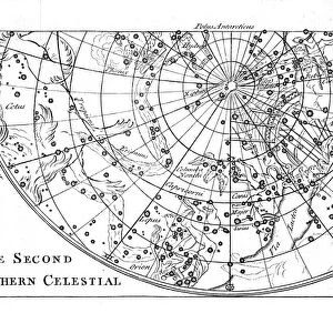
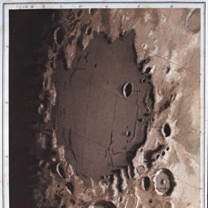
Canvas Print : Second part of the star chart of the Northern Celestial Hemisphere showing constellations, 1747


![]()
Canvas Prints From Heritage Images
Second part of the star chart of the Northern Celestial Hemisphere showing constellations, 1747
Heritage Images features heritage image collections
Media ID 14862987
© Oxford Science Archive / Heritage-Images
Astronomical Chart Astronomical Map Cartography Constellation Map Making Night Sky Northern Hemisphere Oxford Science Archive Star
30"x20" (76x51cm) Canvas Print
Discover the wonders of the night sky with our Media Storehouse Canvas Prints featuring the second part of the historic star chart of the Northern Celestial Hemisphere, dating back to 1747. This captivating image from Heritage Images showcases intricately detailed constellations, transporting you on a journey through the cosmos. Our premium canvas prints are meticulously crafted using high-quality materials, ensuring vibrant colors and sharp details that bring this celestial masterpiece to life in your home or office. Elevate your space with a touch of history and the beauty of the universe.
Delivered stretched and ready to hang our premium quality canvas prints are made from a polyester/cotton blend canvas and stretched over a 1.25" (32mm) kiln dried knot free wood stretcher bar. Packaged in a plastic bag and secured to a cardboard insert for safe transit.
Canvas Prints add colour, depth and texture to any space. Professionally Stretched Canvas over a hidden Wooden Box Frame and Ready to Hang
Estimated Product Size is 76.2cm x 50.8cm (30" x 20")
These are individually made so all sizes are approximate
Artwork printed orientated as per the preview above, with landscape (horizontal) orientation to match the source image.
FEATURES IN THESE COLLECTIONS
> Maps and Charts
> Related Images
> Maps and Charts
> Star Charts
EDITORS COMMENTS
This print showcases the second part of a star chart from 1747, depicting the Northern Celestial Hemisphere with its mesmerizing constellations. Created by an unknown cartographer, this intricate engraving is a testament to the scientific advancements and fascination with astronomy during the 18th century. The detailed map offers a glimpse into the night sky as seen centuries ago, providing valuable insights into celestial navigation and exploration. Each constellation is meticulously illustrated, allowing viewers to trace their favorite stars or discover new ones in this monochrome masterpiece. As we admire this exquisite piece of artistry, it serves as a reminder of humanity's enduring curiosity about our place in the universe. The craftsmanship involved in map making during that era shines through in every line and curve on this historical document. Preserved by Oxford Science Archive, this print transports us back to a time when astronomers relied on such charts for their research and observations. It invites us to ponder how far we have come since then while appreciating the foundations laid by those who came before us. Whether you are an astronomy enthusiast or simply appreciate fine art, this stunning print will undoubtedly captivate your imagination as you explore the wonders of our cosmic neighborhood.
MADE IN THE USA
Safe Shipping with 30 Day Money Back Guarantee
FREE PERSONALISATION*
We are proud to offer a range of customisation features including Personalised Captions, Color Filters and Picture Zoom Tools
FREE COLORIZATION SERVICE
You can choose advanced AI Colorization for this picture at no extra charge!
SECURE PAYMENTS
We happily accept a wide range of payment options so you can pay for the things you need in the way that is most convenient for you
* Options may vary by product and licensing agreement. Zoomed Pictures can be adjusted in the Basket.