Canvas Print > Europe > United Kingdom > Scotland > Edinburgh > Edinburgh
Canvas Print : Commercial Map of the World, 1902. Creator: Unknown


![]()
Canvas Prints From Heritage Images
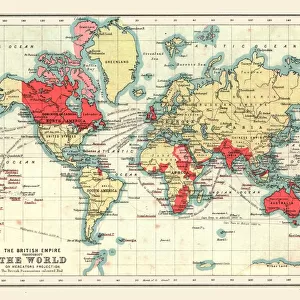
Commercial Map of the World, 1902. Creator: Unknown
Commercial Map of the World, 1902. With shipping routes. From The Century Atlas of the World. [John Walker & Co, Ltd. London, 1902]
Heritage Images features heritage image collections
Media ID 15512554
© The Print Collector / Heritage-Images
Cartography Commerce Edinburgh Geographical Institute Map Making Shipping Route Trade Route World Mercator Projection
20"x16" (51x41cm) Canvas Print
Step back in time with our stunning Canvas Print of the Commercial Map of the World, 1902 from Media Storehouse. This captivating vintage map, sourced from Heritage Images, showcases the world as it was over a century ago. With intricate details of shipping routes, this map is a testament to the global commerce of the early 20th century. Add an element of history and charm to your space with this unique and intriguing Canvas Print. Note: Creator is unknown, but it is from The Century Atlas of the World published by John Walker & Co, Ltd, London, 1902.
Delivered stretched and ready to hang our premium quality canvas prints are made from a polyester/cotton blend canvas and stretched over a 1.25" (32mm) kiln dried knot free wood stretcher bar. Packaged in a plastic bag and secured to a cardboard insert for safe transit.
Canvas Prints add colour, depth and texture to any space. Professionally Stretched Canvas over a hidden Wooden Box Frame and Ready to Hang
Estimated Product Size is 50.8cm x 40.6cm (20" x 16")
These are individually made so all sizes are approximate
Artwork printed orientated as per the preview above, with landscape (horizontal) orientation to match the source image.
FEATURES IN THESE COLLECTIONS
> Europe
> United Kingdom
> Scotland
> Edinburgh
> Edinburgh
> Europe
> United Kingdom
> Scotland
> Lothian
> Edinburgh
> Maps and Charts
> Related Images
> Maps and Charts
> World
EDITORS COMMENTS
This print showcases a remarkable piece of cartographic history - the "Commercial Map of the World, 1902". Created by an unknown artist and featured in The Century Atlas of the World, this map offers a fascinating glimpse into global commerce during the early 20th century. With its vibrant colors and meticulous details, it provides valuable insights into trade routes and shipping networks that shaped our interconnected world. The Mercator projection employed in this map allows for accurate representation of landmasses while highlighting major trade routes across continents. Produced by John Walker & Co Ltd. , London, it reflects their commitment to precision and excellence in map making. Notably, Edinburgh Geographical Institute's expertise is also evident in this masterpiece. As we explore this print further, we are transported back to an era when international trade was expanding rapidly. The intricate web of shipping routes depicted on the map serves as a visual reminder of how goods were transported across oceans to reach distant markets. It symbolizes the interdependence between nations and underscores the significance of commerce as a driving force behind globalization. While we marvel at this historical artifact from The Print Collector collection, let us appreciate its artistic beauty and acknowledge its contribution to our understanding of geography and economic history. This print invites us to reflect upon how far we have come since 1902 while recognizing that many aspects of global trade remain fundamental pillars shaping our modern society today.
MADE IN THE USA
Safe Shipping with 30 Day Money Back Guarantee
FREE PERSONALISATION*
We are proud to offer a range of customisation features including Personalised Captions, Color Filters and Picture Zoom Tools
SECURE PAYMENTS
We happily accept a wide range of payment options so you can pay for the things you need in the way that is most convenient for you
* Options may vary by product and licensing agreement. Zoomed Pictures can be adjusted in the Basket.