
Mercator Projection Collection
The Mercator Projection: Unveiling the World's Grandeur Step into a world of exploration and discovery with the Mercator Projection


All Professionally Made to Order for Quick Shipping
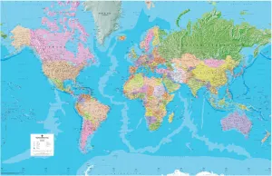
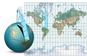
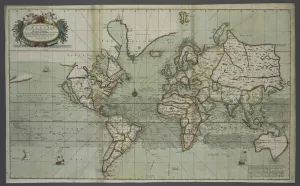
The Mercator Projection: Unveiling the World's Grandeur Step into a world of exploration and discovery with the Mercator Projection, a giant world map that has revolutionized cartography. This remarkable creation showcases the vastness of our planet, capturing its diverse landscapes and oceans in stunning detail. At first glance, your eyes are drawn to the intricate compass rose at its center, guiding you through this visual masterpiece. As you explore further, your gaze is captivated by the Indian Ocean, shimmering like a jewel amidst continents. From Melanesia to Magellan's round-the-world voyage in 1519-1521, every corner of our globe comes alive on this magnificent map. Travel back in time as you encounter historical snapshots etched onto this captivating canvas. A glimpse into British imperialism unfolds before your eyes with a World Map showing the British Empire from 1902. The mysteries of uncharted territories unravel as an unknown creator unveils a Map of the Indian Ocean from that same year. Embark on an adventure across borders and cultures with Commercial Map of the World from 1902. Its vibrant colors beckon you to explore distant lands and embrace their unique charm. Dive deep into oceanic depths or soar high above mountain peaks with another enigmatic creation - Map of the World showing Heights and Depths. Navigate through treacherous waters with Chart of North Atlantic from 1902; let it guide you safely towards new horizons while evoking tales of maritime conquests past. Finally, immerse yourself in Gerardus Mercator's genius - a visionary geographer who crafted this projection during his lifetime (1512-1594), forever leaving his mark on cartography. As if transported back centuries ago, witness Double Hemisphere World Maps colored engravings from 1587 grace these walls once more – their artistry reminding us how far we've come yet how much remains unchanged.