Canvas Print > Europe > Spain > Related Images
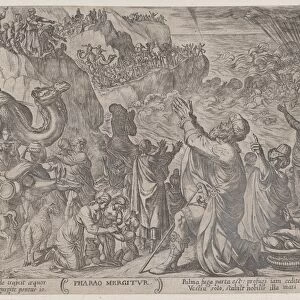
Canvas Print : NEW WORLD MAP, 1554. Engraved map of the New World from the Spanish conquistador Pedro Cieza de Leons Chronicle of Peru, published in Antwerp, 1554


![]()
Canvas Prints From Granger
NEW WORLD MAP, 1554. Engraved map of the New World from the Spanish conquistador Pedro Cieza de Leons Chronicle of Peru, published in Antwerp, 1554
Granger holds millions of images spanning more than 25,000 years of world history, from before the Stone Age to the dawn of the Space Age
Media ID 7537353
1554 Conquistador De Leon New World North America Pedro Ship South America Spanish
20"x16" (51x41cm) Canvas Print
Step back in time with our captivating Canvas Print of the New World Map, 1554. This exquisite piece showcases an engraved map of the New World, taken from the Spanish conquistador Pedro Cieza de Leon's Chronicle of Peru, published in Antwerp in 1554. The intricate details of this historical map bring the exploration and discovery of the New World to life. Our high-quality Canvas Prints are made using premium materials and vibrant inks, ensuring your piece remains a stunning addition to your home or office for years to come. Bring history into your space with this mesmerizing New World Map, 1554 Canvas Print from Media Storehouse and The Granger Collection.
Delivered stretched and ready to hang our premium quality canvas prints are made from a polyester/cotton blend canvas and stretched over a 1.25" (32mm) kiln dried knot free wood stretcher bar. Packaged in a plastic bag and secured to a cardboard insert for safe transit.
Canvas Prints add colour, depth and texture to any space. Professionally Stretched Canvas over a hidden Wooden Box Frame and Ready to Hang
Estimated Product Size is 40.6cm x 50.8cm (16" x 20")
These are individually made so all sizes are approximate
Artwork printed orientated as per the preview above, with portrait (vertical) orientation to match the source image.
FEATURES IN THESE COLLECTIONS
> Europe
> Spain
> Related Images
> North America
> Related Images
> South America
> Peru
> Related Images
> South America
> Related Images
EDITORS COMMENTS
This print showcases a remarkable piece of history - the "NEW WORLD MAP, 1554". Engraved by the renowned Spanish conquistador Pedro Cieza de Leon, this map offers an intriguing glimpse into the exploration and conquest of the New World during the 16th century. Published in Antwerp in 1554 as part of Cieza de Leon's Chronicle of Peru, this engraving provides a visual representation of the vast territories discovered by European explorers. The map depicts both North and South America, with intricate details that highlight various regions and landmarks. It serves as a testament to the ambition and curiosity that drove these early adventurers to embark on perilous journeys across uncharted waters. As we gaze upon this image, we are transported back in time to an era when discovery was synonymous with adventure. The ships depicted on the map symbolize not only transportation but also colonization and trade routes that forever altered global history. Through this print from Granger Art on Demand's Carousel Collection, we can appreciate not only the artistic beauty of Cieza de Leon's engraving but also its historical significance. It reminds us of how our understanding of geography has evolved over centuries and how exploration continues to shape our world today.
MADE IN THE USA
Safe Shipping with 30 Day Money Back Guarantee
FREE PERSONALISATION*
We are proud to offer a range of customisation features including Personalised Captions, Color Filters and Picture Zoom Tools
FREE COLORIZATION SERVICE
You can choose advanced AI Colorization for this picture at no extra charge!
SECURE PAYMENTS
We happily accept a wide range of payment options so you can pay for the things you need in the way that is most convenient for you
* Options may vary by product and licensing agreement. Zoomed Pictures can be adjusted in the Basket.