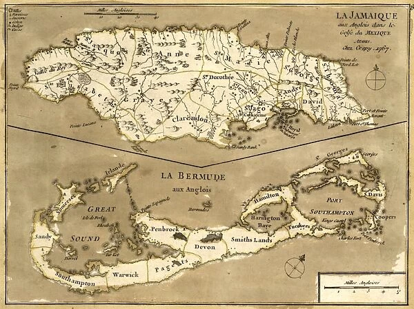
Canvas Print : MAP: JAMAICA, 1767. French map of the islands of Jamaica and Bermuda, published 1767
![]()

Canvas Prints from Granger
MAP: JAMAICA, 1767. French map of the islands of Jamaica and Bermuda, published 1767
MAP: JAMAICA, 1767.
French map of the islands of Jamaica and Bermuda, published 1767
Granger holds millions of images spanning more than 25,000 years of world history, from before the Stone Age to the dawn of the Space Age
Media ID 12321402
20"x16" (51x41cm) Canvas Print
Step back in time with our exquisite Canvas Print of the 1767 French map of Jamaica and Bermuda by Granger, NYC / The Granger Collection. This detailed and captivating antique map, published over 250 years ago, showcases the historical geography of the Caribbean islands of Jamaica and Bermuda. The rich, textured canvas brings out the intricate details of the map's vibrant colors and intricate lines, making it a stunning addition to any room in your home or office. Travel back in time and adorn your walls with a piece of history.
Delivered stretched and ready to hang our premium quality canvas prints are made from a polyester/cotton blend canvas and stretched over a 1.25" (32mm) kiln dried knot free wood stretcher bar. Packaged in a plastic bag and secured to a cardboard insert for safe transit.
Canvas Prints add colour, depth and texture to any space. Professionally Stretched Canvas over a hidden Wooden Box Frame and Ready to Hang
Estimated Product Size is 50.8cm x 40.6cm (20" x 16")
These are individually made so all sizes are approximate
Artwork printed orientated as per the preview above, with landscape (horizontal) orientation to match the source image.
EDITORS COMMENTS
This print showcases a remarkable piece of history - a French map from 1767 depicting the islands of Jamaica and Bermuda. The intricate engraving, done in sepia tones, transports us back to the mid-18th century when cartography was both an art form and a scientific endeavor. The map itself is a testament to the meticulous craftsmanship of its creator, capturing every detail with precision and accuracy. It offers a glimpse into the geographical knowledge of that era, showcasing not only the coastlines but also topographical features such as mountains and rivers. As we study this vintage map, we can't help but marvel at how different these Caribbean islands must have been during colonial times. The names of towns and cities evoke images of bustling ports and vibrant communities shaped by European influences. Beyond its historical significance, this print serves as a reminder of the power maps hold in shaping our understanding of the world. They are windows into different periods in time, allowing us to explore distant lands without leaving our homes. Granger Art on Demand has expertly preserved this exquisite piece from their collection for all to appreciate. It is through such prints that we can continue to celebrate art's ability to transport us across time and space while honoring those who meticulously crafted these works centuries ago.
MADE IN THE USA
Safe Shipping with 30 Day Money Back Guarantee
FREE PERSONALISATION*
We are proud to offer a range of customisation features including Personalised Captions, Color Filters and Picture Zoom Tools
SECURE PAYMENTS
We happily accept a wide range of payment options so you can pay for the things you need in the way that is most convenient for you
* Options may vary by product and licensing agreement. Zoomed Pictures can be adjusted in the Cart.


