Canvas Print > Arts > Artists > S > Walter Smalling
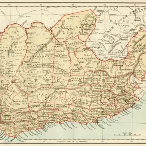
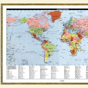
Canvas Print : MAP: BRITISH EMPIRE, 1886. Map, 1886, of the British Empire by Walter Crane


Canvas Prints from Granger
MAP: BRITISH EMPIRE, 1886. Map, 1886, of the British Empire by Walter Crane
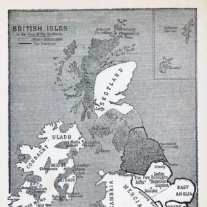
MAP: BRITISH EMPIRE, 1886. Map, 1886, of the British Empire by Walter Crane. The small insert shows, in red, the extent of the British territories in 1786
Granger holds millions of images spanning more than 25,000 years of world history, from before the Stone Age to the dawn of the Space Age
Media ID 6620137
1886 Arts And Crafts Movement British Empire Colonialism Crane Walter World
20"x16" (51x41cm) Canvas Print
Introducing the captivating and historically significant Canvas Print of the "British Empire, 1886" map by Walter Crane, from The Granger Collection. This exquisite piece, available through Media Storehouse and Granger Art on Demand, offers a fascinating glimpse into the past. Walter Crane's intricately detailed map illustrates the vast expanse of the British Empire at its zenith in 1886. The red overlay reveals the territories under British rule compared to the earlier map from 1786, providing a compelling visual representation of the empire's growth over the centuries. Our premium Canvas Prints are meticulously crafted to bring out the rich colors and intricate details of this historical masterpiece. Each print is carefully printed using archival inks on high-quality canvas, ensuring a stunning, long-lasting display that will add depth and character to any room. Bring a piece of history into your home or office with the "British Empire, 1886" Canvas Print from Media Storehouse and Granger Art on Demand. Order yours today and embark on a captivating journey through time.
Delivered stretched and ready to hang our premium quality canvas prints are made from a polyester/cotton blend canvas and stretched over a 1.25" (32mm) kiln dried knot free wood stretcher bar. Packaged in a plastic bag and secured to a cardboard insert for safe transit.
Canvas Prints add colour, depth and texture to any space. Professionally Stretched Canvas over a hidden Wooden Box Frame and Ready to Hang
Estimated Image Size (if not cropped) is 50.8cm x 37.5cm (20" x 14.8")
Estimated Product Size is 50.8cm x 40.6cm (20" x 16")
These are individually made so all sizes are approximate
Artwork printed orientated as per the preview above, with landscape (horizontal) orientation to match the source image.
FEATURES IN THESE COLLECTIONS
> Arts
> Artists
> C
> Walter Crane
> Arts
> Artists
> S
> Walter Smalling
> Maps and Charts
> British Empire Maps
> Maps and Charts
> Popular Maps
> Maps and Charts
> Related Images
> Maps and Charts
> World
> Granger Art on Demand
> Maps
EDITORS COMMENTS
This print showcases a historical map of the British Empire in 1886, masterfully created by Walter Crane. The intricate details and vibrant colors bring to life the vast expanse of territories under British rule during this era. As one explores the map, it becomes evident that the empire spanned across continents and oceans, leaving an indelible mark on world history. Walter Crane's artistic prowess is evident in this piece as he skillfully captures not only geographical accuracy but also conveys a sense of grandeur and power associated with colonialism. The inclusion of a small insert highlighting the extent of British territories in 1786 adds depth to our understanding of how much the empire expanded over time. This artwork serves as a poignant reminder of the late colonial period when Britain held significant global influence. It encapsulates an important chapter in world history, shedding light on both the achievements and controversies surrounding imperialism. As part of the Arts and Crafts movement, Walter Crane's work embodies his commitment to combining aesthetics with social commentary. This particular map print stands as a testament to his talent for merging artistry with education. The Granger Collection has once again curated an exceptional piece that invites viewers to delve into history through visual storytelling. Whether displayed at home or in educational settings, this print is sure to spark curiosity and ignite conversations about past empires' legacies.
MADE IN THE USA
Safe Shipping with 30 Day Money Back Guarantee
FREE PERSONALISATION*
We are proud to offer a range of customisation features including Personalised Captions, Color Filters and Picture Zoom Tools
SECURE PAYMENTS
We happily accept a wide range of payment options so you can pay for the things you need in the way that is most convenient for you
* Options may vary by product and licensing agreement. Zoomed Pictures can be adjusted in the Cart.