Canvas Print > Aerial Photography > Related Images
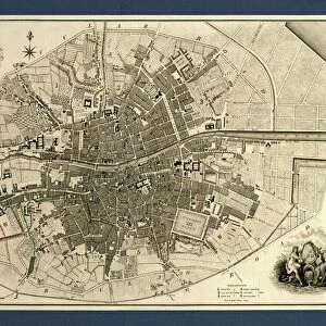
Canvas Print : Springfield Missouri US City Street Map


![]()
Canvas Prints From Fine Art Storehouse
Springfield Missouri US City Street Map
Vector Illustration of a City Street Map of Springfield, Missouri, USA. Scale 1:60, 000.
All source data is in the public domain.
U.S. Geological Survey, US Topo
Used Layers:
USGS The National Map: National Hydrography Dataset (NHD)
USGS The National Map: National Transportation Dataset (NTD)
Unleash your creativity and transform your space into a visual masterpiece!
Frank Ramspott
Media ID 15215780
© Frank Ramspott, all rights reserved
Aerial View City Map Computer Graphic Directly Above Downtown District Gray Missouri Road Map Text Digitally Generated Image Green Color Springfield White Color
20"x16" (51x41cm) Canvas Print
Bring the charm of Springfield, Missouri, right into your home with our Canvas Print of the City Street Map by Frank Ramspott from Media Storehouse. This stunning, high-quality canvas print features a detailed vector illustration of the city, showcasing the U.S. landmark with a scale of 1:60,000. The public domain source data guarantees an authentic representation of Springfield's streets. Elevate your decor with this unique and captivating piece of art, perfect for both personal enjoyment and as a thoughtful gift.
Delivered stretched and ready to hang our premium quality canvas prints are made from a polyester/cotton blend canvas and stretched over a 1.25" (32mm) kiln dried knot free wood stretcher bar. Packaged in a plastic bag and secured to a cardboard insert for safe transit.
Canvas Prints add colour, depth and texture to any space. Professionally Stretched Canvas over a hidden Wooden Box Frame and Ready to Hang
Estimated Product Size is 40.6cm x 50.8cm (16" x 20")
These are individually made so all sizes are approximate
Artwork printed orientated as per the preview above, with portrait (vertical) orientation to match the source image.
FEATURES IN THESE COLLECTIONS
> Aerial Photography
> Related Images
> Animals
> Insects
> Hemiptera
> Green Scale
> Arts
> Contemporary art
> Digital artwork
> Street art
> Arts
> Street art graffiti
> Digital art
> Digital paintings
> Arts
> Street art graffiti
> Digital art
> Vector illustrations
> Maps and Charts
> Geological Map
> Maps and Charts
> Related Images
> North America
> United States of America
> Lakes
> Related Images
> North America
> United States of America
> Maps
> North America
> United States of America
> Missouri
> Related Images
EDITORS COMMENTS
This vibrant and detailed print showcases the city streets of Springfield, Missouri, USA. With a scale of 1:60,000, this vector illustration provides an accurate representation of the downtown district, complete with its lake and river. The map is designed using various layers from reliable sources such as USGS The National Map: National Hydrography Dataset (NHD) and USGS The National Map: National Transportation Dataset (NTD). Created by Frank Ramspott, this digitally generated image captures the essence of Springfield's urban landscape without any people present. The color palette includes shades of gray, blue, white, and green to depict different features on the map. From roads to streets and everything in between, every detail has been meticulously crafted. With its aerial view directly above the cityscape, this print offers a unique perspective on Springfield's physical geography. Whether you are a resident or visitor looking for navigation assistance or simply appreciate cartography as an art form, this piece is sure to captivate your attention
MADE IN THE USA
Safe Shipping with 30 Day Money Back Guarantee
FREE PERSONALISATION*
We are proud to offer a range of customisation features including Personalised Captions, Color Filters and Picture Zoom Tools
SECURE PAYMENTS
We happily accept a wide range of payment options so you can pay for the things you need in the way that is most convenient for you
* Options may vary by product and licensing agreement. Zoomed Pictures can be adjusted in the Basket.