Home > North America > United States of America > Missouri > Independence
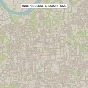
Independence Missouri US City Street Map

![]()
Wall Art and Photo Gifts from Fine Art Storehouse
Independence Missouri US City Street Map
Vector Illustration of a City Street Map of Independence, Missouri, USA. Scale 1:60, 000.
All source data is in the public domain.
U.S. Geological Survey, US Topo
Used Layers:
USGS The National Map: National Hydrography Dataset (NHD)
USGS The National Map: National Transportation Dataset (NTD)
Unleash your creativity and transform your space into a visual masterpiece!
Frank Ramspott
Media ID 15215784
© Frank Ramspott, all rights reserved
Aerial View City Map Computer Graphic Directly Above Downtown District Gray Independence Missouri Road Map Text Digitally Generated Image Green Color White Color
FEATURES IN THESE COLLECTIONS
> Aerial Photography
> Related Images
> Animals
> Insects
> Hemiptera
> Green Scale
> Arts
> Landscape paintings
> Waterfall and river artworks
> River artworks
> Arts
> Portraits
> Pop art gallery
> Street art portraits
> Fine Art Storehouse
> Map
> Street Maps
> Fine Art Storehouse
> Map
> USA Maps
> Maps and Charts
> Geological Map
> North America
> United States of America
> Lakes
> Related Images
> North America
> United States of America
> Maps
> North America
> United States of America
> Missouri
> Independence
EDITORS COMMENTS
This print showcases a meticulously detailed city street map of Independence, Missouri, USA. With a scale of 1:60,000, this vector illustration provides an accurate depiction of the city's downtown district, complete with its bustling streets and vibrant energy. The map also highlights significant features such as the nearby lake and river, adding to the charm and character of this historic town. Created by Frank Ramspott using publicly available data from the U. S. Geological Survey (USGS), specifically The National Map: National Hydrography Dataset (NHD) and National Transportation Dataset (NTD), this digitally generated image is a testament to his exceptional cartography skills. Every road and pathway has been intricately designed in shades of gray, blue, white, and green colors that perfectly complement each other. With no people present in the image itself, viewers are invited to immerse themselves solely in the physical geography depicted from an aerial perspective directly above Independence. This stunning piece effortlessly combines artistry with functionality as it serves both as a visually appealing design element for any space while also providing valuable navigational information. Whether you're an Independence local or simply appreciate beautiful maps that capture the essence of a place so well, this print is sure to be a delightful addition to your collection.
MADE IN THE USA
Safe Shipping with 30 Day Money Back Guarantee
FREE PERSONALISATION*
We are proud to offer a range of customisation features including Personalised Captions, Color Filters and Picture Zoom Tools
SECURE PAYMENTS
We happily accept a wide range of payment options so you can pay for the things you need in the way that is most convenient for you
* Options may vary by product and licensing agreement. Zoomed Pictures can be adjusted in the Cart.