Canvas Print > Arts > Minimalist artwork > Simple artwork > Textured artwork
Canvas Print : Simple UK map


Canvas Prints from Fine Art Storehouse
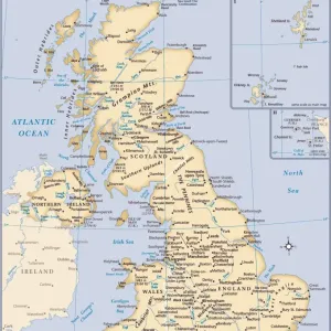
Simple UK map
A simple UK map with roads and major towns and cities named. There is a very slight grunge texture on sea and land, this is on separate layers and are easy to remove. 11 layers in all
Unleash your creativity and transform your space into a visual masterpiece!
Media ID 15054255
20"x16" (51x41cm) Canvas Print
Introducing the "Simple UK Map" Canvas Print from Media Storehouse's Fine Art Storehouse collection. This exquisite piece showcases a clear and detailed representation of the United Kingdom, complete with named roads and major towns and cities. The design features a subtle grunge texture on both the land and sea, adding an elegant and distinct character. With 11 separate layers, customization is a breeze - easily remove the grunge texture or adjust it to your preference. Bring the beauty of the UK right into your home with this captivating canvas print.
Delivered stretched and ready to hang our premium quality canvas prints are made from a polyester/cotton blend canvas and stretched over a 1.25" (32mm) kiln dried knot free wood stretcher bar. Packaged in a plastic bag and secured to a cardboard insert for safe transit.
Canvas Prints add colour, depth and texture to any space. Professionally Stretched Canvas over a hidden Wooden Box Frame and Ready to Hang
Estimated Product Size is 40.6cm x 50.8cm (16" x 20")
These are individually made so all sizes are approximate
Artwork printed orientated as per the preview above, with portrait (vertical) orientation to match the source image.
FEATURES IN THESE COLLECTIONS
> Arts
> Minimalist artwork
> Simple artwork
> Textured artwork
> Europe
> France
> Canton
> Landes
> Europe
> United Kingdom
> Maps
> Maps and Charts
> Related Images
> Fine Art Storehouse
> Map
> Reference Maps
> Fine Art Storehouse
> Top Sellers - Art Prints
EDITORS COMMENTS
This print showcases a beautifully designed and detailed map of the United Kingdom. With roads, major towns, and cities clearly labeled, it serves as an excellent reference for both locals and visitors alike. The simplicity of the design allows for easy navigation while retaining its aesthetic appeal. The artist has added a subtle grunge texture to the sea and land areas, giving the map a unique touch. This texture is on separate layers, allowing viewers to choose whether they prefer a clean or slightly weathered look. With 11 layers in total, this print offers versatility and customization options. Ideal for home decor or office spaces, this map print captures the essence of the UK's geography with precision and style. Whether you're planning your next adventure or simply appreciating its artistic value, this piece will surely spark curiosity and conversation among admirers.
MADE IN THE USA
Safe Shipping with 30 Day Money Back Guarantee
FREE PERSONALISATION*
We are proud to offer a range of customisation features including Personalised Captions, Color Filters and Picture Zoom Tools
SECURE PAYMENTS
We happily accept a wide range of payment options so you can pay for the things you need in the way that is most convenient for you
* Options may vary by product and licensing agreement. Zoomed Pictures can be adjusted in the Cart.