Canvas Print > North America > United States of America > New York > New York > Maps
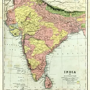
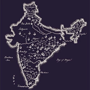
Canvas Print : Map of Northern India 1894


![]()
Canvas Prints from Fine Art Storehouse
Map of Northern India 1894
Johnsons Universal Cyclopedia - Volume IV New York - A. J. Johnson Company 1894
Unleash your creativity and transform your space into a visual masterpiece!
THEPALMER
Media ID 18356729
20"x16" (51x41cm) Canvas Print
Step back in time with our exquisite Canvas Print of a historical Map of Northern India from 1894, sourced from ThePalmer's contribution to Johnsons Universal Cyclopedia. This fine art piece, brought to you by Media Storehouse from the Fine Art Storehouse, beautifully captures the intricate details of the geography and political boundaries of Northern India during that era. The rich, textured canvas adds depth and dimension to the intriguing vintage map, making it a captivating addition to any room in your home or office. Embrace the charm of history with this unique and thought-provoking artwork.
Delivered stretched and ready to hang our premium quality canvas prints are made from a polyester/cotton blend canvas and stretched over a 1.25" (32mm) kiln dried knot free wood stretcher bar. Packaged in a plastic bag and secured to a cardboard insert for safe transit.
Canvas Prints add colour, depth and texture to any space. Professionally Stretched Canvas over a hidden Wooden Box Frame and Ready to Hang
Estimated Product Size is 50.8cm x 40.6cm (20" x 16")
These are individually made so all sizes are approximate
Artwork printed orientated as per the preview above, with landscape (horizontal) orientation to match the source image.
FEATURES IN THESE COLLECTIONS
> Asia
> India
> Related Images
> Maps and Charts
> India
> Maps and Charts
> Related Images
> North America
> United States of America
> New York
> New York
> Maps
> North America
> United States of America
> New York
> Related Images
> Fine Art Storehouse
> Map
> Historical Maps
EDITORS COMMENTS
In this print titled "Map of Northern India 1894" we are transported back in time to the late 19th century, immersing ourselves in the rich history and intricate geography of a region that has long fascinated explorers and scholars alike. The map, sourced from Johnsons Universal Cyclopedia - Volume IV New York - A. J. Johnson Company 1894, is a testament to both the artistry and scientific precision of cartography during this era. As our eyes wander across the aged parchment, we discover an array of meticulously drawn details that bring Northern India's diverse landscape to life. From majestic mountain ranges like the Himalayas, standing tall as guardians of ancient traditions and cultures, to winding rivers such as the Ganges, etching their way through lush plains teeming with vibrant cities and sacred sites. The craftsmanship evident in every stroke speaks volumes about the dedication and expertise required to create such a comprehensive depiction of a vast land brimming with historical significance. It serves as a reminder that maps were once cherished works of art themselves – gateways into uncharted territories waiting to be explored. Through THEPALMER's lens at Fine Art Storehouse, this particular print captures not only an extraordinary piece of geographical documentation but also invites us on an imaginative journey through time. It allows us to appreciate how far we have come while igniting curiosity about what lies beyond those carefully inked borders—a true treasure for any history enthusiast or lover of fine art seeking connection with bygone eras
MADE IN THE USA
Safe Shipping with 30 Day Money Back Guarantee
FREE PERSONALISATION*
We are proud to offer a range of customisation features including Personalised Captions, Color Filters and Picture Zoom Tools
SECURE PAYMENTS
We happily accept a wide range of payment options so you can pay for the things you need in the way that is most convenient for you
* Options may vary by product and licensing agreement. Zoomed Pictures can be adjusted in the Cart.