Canvas Print > Europe > Spain > Maps
Canvas Print : Map of Madrid


![]()
Canvas Prints From Fine Art Storehouse
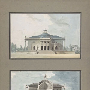
Map of Madrid
Antique map of Madrid from 1898
Unleash your creativity and transform your space into a visual masterpiece!
Nastasic
Media ID 21086515
© Nikola Nastasic
Chart Diagram European Culture Madrid Plan Spanish Culture Urban Scene Drawing Art Product Image Created 19th Century Painted Image
30"x20" (76x51cm) Canvas Print
Step back in time with our exquisite Canvas Print of the Antique Map of Madrid by Nastasic from the Fine Art Storehouse collection at Media Storehouse. This stunning piece showcases an intricately detailed map of the Spanish capital city as it appeared in 1898. Each canvas print is meticulously crafted using premium materials, ensuring vibrant colors and sharp details that bring history to life. Hang this beautiful work of art in your home or office to add a touch of timeless charm and sophistication to your space.
Delivered stretched and ready to hang our premium quality canvas prints are made from a polyester/cotton blend canvas and stretched over a 1.25" (32mm) kiln dried knot free wood stretcher bar. Packaged in a plastic bag and secured to a cardboard insert for safe transit.
Canvas Prints add colour, depth and texture to any space. Professionally Stretched Canvas over a hidden Wooden Box Frame and Ready to Hang
Estimated Product Size is 50.8cm x 76.2cm (20" x 30")
These are individually made so all sizes are approximate
Artwork printed orientated as per the preview above, with portrait (vertical) orientation to match the source image.
FEATURES IN THESE COLLECTIONS
> Maps and Charts
> Related Images
> Maps and Charts
> Spain
> Fine Art Storehouse
> Map
> Historical Maps
EDITORS COMMENTS
This print showcases an exquisite antique map of Madrid, dating back to the year 1898. A true masterpiece of cartography, this image immerses us in the rich European culture and invites us on a journey through time. With its intricate details and meticulous craftsmanship, it serves as both a valuable tool for travelers and a work of art that captures the essence of Spanish history. The painted image transports us to the vibrant streets of Madrid, offering a glimpse into its urban scene during the late 19th century. As we explore this meticulously illustrated map, we are reminded of how cities evolve over time while still preserving their unique charm. The fusion between science and art is evident in this remarkable piece. The diagrammatic representation not only provides geographical information but also reflects the artistic sensibilities prevalent during that era. It stands as a testament to human ingenuity in capturing complex concepts through visual means. With its historical significance and cultural relevance, this artwork celebrates Spanish heritage by showcasing Madrid's architectural landmarks and city layout from yesteryears. It sparks curiosity about how these spaces have transformed over generations while retaining their distinct identity. As we gaze upon Nastasic's creation, our imagination takes flight with thoughts of exploring every corner depicted on this mesmerizing chart. This print truly encapsulates the spirit of travel and tourism while serving as an invaluable window into Spain's capital city - Madrid
MADE IN THE USA
Safe Shipping with 30 Day Money Back Guarantee
FREE PERSONALISATION*
We are proud to offer a range of customisation features including Personalised Captions, Color Filters and Picture Zoom Tools
SECURE PAYMENTS
We happily accept a wide range of payment options so you can pay for the things you need in the way that is most convenient for you
* Options may vary by product and licensing agreement. Zoomed Pictures can be adjusted in the Basket.