Canvas Print > North America > United States of America > New York > Related Images
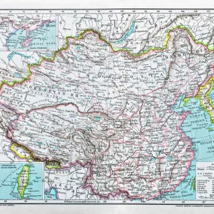
Canvas Print : China Map 1893


![]()
Canvas Prints From Fine Art Storehouse
China Map 1893
Johnsonas Universal Cyclopedia - Charles Kendall - New York 1893 vol 2
Unleash your creativity and transform your space into a visual masterpiece!
THEPALMER
Media ID 14756546
© This content is subject to copyright
20"x16" (51x41cm) Canvas Print
Discover the rich history of China with our exquisite Canvas Print of the 1893 China Map by THEPALMER from the Media Storehouse Fine Art Storehouse collection. This captivating map, taken from the pages of Johnsonas Universal Cyclopedia, offers a fascinating glimpse into the political and geographical landscape of China during that era. The high-quality canvas print brings the intricate details and vibrant colors of the map to life, making it a stunning addition to any home or office. Transport yourself back in time and add a touch of historical charm to your space with this beautiful and authentic piece of cartographic art.
Delivered stretched and ready to hang our premium quality canvas prints are made from a polyester/cotton blend canvas and stretched over a 1.25" (32mm) kiln dried knot free wood stretcher bar. Packaged in a plastic bag and secured to a cardboard insert for safe transit.
Canvas Prints add colour, depth and texture to any space. Professionally Stretched Canvas over a hidden Wooden Box Frame and Ready to Hang
Estimated Product Size is 50.8cm x 40.6cm (20" x 16")
These are individually made so all sizes are approximate
Artwork printed orientated as per the preview above, with landscape (horizontal) orientation to match the source image.
FEATURES IN THESE COLLECTIONS
> Asia
> Related Images
> North America
> United States of America
> New York
> Related Images
> Fine Art Storehouse
> Map
> Historical Maps
EDITORS COMMENTS
This print titled "China Map 1893" takes us on a historical journey back to the late 19th century. The image showcases an intricately detailed map, sourced from Johnson's Universal Cyclopedia by Charles Kendall, published in New York in 1893. This vintage piece of cartography offers a fascinating glimpse into the geopolitical landscape of Asia during that era. The map encompasses not only China but also neighboring regions such as Japan and Mongolia, providing a comprehensive view of this vast continent. Its rich colors and meticulous craftsmanship are testaments to the artistry involved in creating such maps before the digital age. "The China Map 1893" invites us to explore the intricate details etched onto its surface—mountain ranges majestically rising from paper, rivers meandering through valleys, and cities marked with tiny dots representing bustling urban centers. It serves as both an educational tool for geography enthusiasts and a window into history for those curious about how borders have evolved over time. Acquired from Fine Art Storehouse, this print by THEPALMER is sure to captivate viewers with its blend of artistic beauty and historical significance. Whether displayed in homes or offices, it adds a touch of elegance while serving as a conversation starter about our world's ever-changing political landscapes throughout history.
MADE IN THE USA
Safe Shipping with 30 Day Money Back Guarantee
FREE PERSONALISATION*
We are proud to offer a range of customisation features including Personalised Captions, Color Filters and Picture Zoom Tools
SECURE PAYMENTS
We happily accept a wide range of payment options so you can pay for the things you need in the way that is most convenient for you
* Options may vary by product and licensing agreement. Zoomed Pictures can be adjusted in the Basket.