Canvas Print > Africa > Related Images
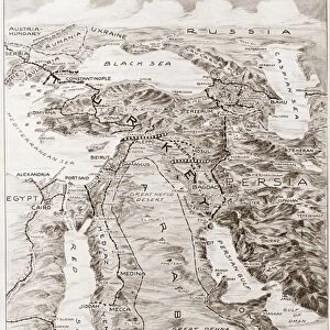
Canvas Print : Antique map of Arabia with the Red Sea and Persian Gulf


![]()
Canvas Prints From Fine Art Storehouse
Antique map of Arabia with the Red Sea and Persian Gulf
Unleash your creativity and transform your space into a visual masterpiece!
Hemera Technologies
Media ID 13667365
© Getty Images
Arabia Arabian Peninsula Direction Document Egypt Geography Indian Ocean Iran Iraq Latitude Legend Location Longitude Middle East Persia Persian Gulf Place Positioning Red Sea Saudi Arabia Title
20"x16" (51x41cm) Canvas Print
Step back in time with our exquisite Antique Map of Arabia Canvas Print from the Media Storehouse Fine Art Collection by Hemera Technologies. This stunning piece showcases intricate detail and vibrant colors, transporting you to a bygone era. The Red Sea and Persian Gulf are beautifully depicted, making this an ideal addition to any room in your home or office. Our high-quality canvas prints are not only visually appealing but also long-lasting, ensuring your investment is protected for years to come. Bring history into your space and add a touch of elegance with this captivating Antique Map of Arabia Canvas Print.
Delivered stretched and ready to hang our premium quality canvas prints are made from a polyester/cotton blend canvas and stretched over a 1.25" (32mm) kiln dried knot free wood stretcher bar. Packaged in a plastic bag and secured to a cardboard insert for safe transit.
Canvas Prints add colour, depth and texture to any space. Professionally Stretched Canvas over a hidden Wooden Box Frame and Ready to Hang
Estimated Product Size is 50.8cm x 40.6cm (20" x 16")
These are individually made so all sizes are approximate
Artwork printed orientated as per the preview above, with landscape (horizontal) orientation to match the source image.
FEATURES IN THESE COLLECTIONS
> Africa
> Related Images
> Fine Art Storehouse
> Map
> Historical Maps
EDITORS COMMENTS
This print showcases an exquisite antique map of Arabia, featuring the mesmerizing Red Sea and Persian Gulf. Crafted with meticulous detail and precision, this archival piece takes us on a journey through time, offering a glimpse into the rich history and geography of the Arabian Peninsula. The intricate engravings depict various key locations such as Egypt, Iraq, Iran, Saudi Arabia, and Persia. The map's elegant design is complemented by a carefully crafted legend that guides us in understanding its physical features. With latitude and longitude lines guiding our way, we can almost feel ourselves transported to this ancient land. As we immerse ourselves in this vintage masterpiece, it becomes evident that it holds immense historical significance. It serves as both a document of past cartography techniques and a testament to the exploratory spirit of early civilizations. Its presence evokes curiosity about the trade routes that once thrived along these shores while reminding us of the region's pivotal role in shaping world history. Photographed horizontally with vibrant colors accentuating its beauty, this print captures every intricate detail for all to admire. In this image devoid of people or modern interference lies an invitation to explore not only geographical landscapes but also our own fascination with history itself.
MADE IN THE USA
Safe Shipping with 30 Day Money Back Guarantee
FREE PERSONALISATION*
We are proud to offer a range of customisation features including Personalised Captions, Color Filters and Picture Zoom Tools
SECURE PAYMENTS
We happily accept a wide range of payment options so you can pay for the things you need in the way that is most convenient for you
* Options may vary by product and licensing agreement. Zoomed Pictures can be adjusted in the Basket.