Canvas Print > Africa > Related Images
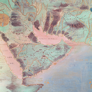
Canvas Print : Ethiopia, the Red Sea and Saudi Arabia, from an Atlas of the World in 33 Maps, Venice


![]()
Canvas Prints From Fine Art Finder
Ethiopia, the Red Sea and Saudi Arabia, from an Atlas of the World in 33 Maps, Venice
XOT330947 Ethiopia, the Red Sea and Saudi Arabia, from an Atlas of the World in 33 Maps, Venice, 1st September 1553 (ink on vellum) (detail from 330946) by Agnese, Battista (1514-64); Museo Correr, Venice, Italy; Italian, out of copyright
Media ID 12852656
© www.bridgemanart.com
East Africa Mapping Monarchs Rulers
20"x16" (51x41cm) Canvas Print
Bring the rich history of cartography into your home with Media Storehouse's Canvas Prints. This stunning piece showcases a detailed map of Ethiopia, the Red Sea, and Saudi Arabia, taken from "An Atlas of the World in 33 Maps, Venice," published on September 1, 1553. Produced by the renowned Venetian cartographer Battista Agnese, this exquisite work of art is a captivating representation of geographical knowledge during the Renaissance era. Our high-quality canvas prints are made to order, ensuring a vibrant and long-lasting display of this intricate and historical map. Transport yourself back in time and add a touch of world exploration to your decor with Media Storehouse's Canvas Prints.
Delivered stretched and ready to hang our premium quality canvas prints are made from a polyester/cotton blend canvas and stretched over a 1.25" (32mm) kiln dried knot free wood stretcher bar. Packaged in a plastic bag and secured to a cardboard insert for safe transit.
Canvas Prints add colour, depth and texture to any space. Professionally Stretched Canvas over a hidden Wooden Box Frame and Ready to Hang
Estimated Product Size is 50.8cm x 40.6cm (20" x 16")
These are individually made so all sizes are approximate
Artwork printed orientated as per the preview above, with landscape (horizontal) orientation to match the source image.
FEATURES IN THESE COLLECTIONS
> Africa
> Ethiopia
> Related Images
> Africa
> Related Images
> Europe
> Italy
> Related Images
EDITORS COMMENTS
This print showcases a detailed map titled "Ethiopia, the Red Sea and Saudi Arabia" from an ancient Atlas of the World in 33 Maps. Created by the talented Italian cartographer Battista Agnese in Venice on 1st September 1553, this ink on vellum masterpiece is now housed at Museo Correr in Venice, Italy. The intricate details of this map transport us back to a time when exploration was limited and knowledge of distant lands was scarce. It offers a glimpse into the geographical understanding of East Africa and the Middle East during that era. Highlighted within this stunning artwork are Ethiopia, the Red Sea, and Saudi Arabia. The precision with which Agnese has depicted these regions demonstrates his mastery as a cartographer. The map not only captures their physical features but also provides insight into political boundaries and rulership during that period. As we admire this historical artifact, it serves as a reminder of how far our understanding of geography has evolved over centuries. It sparks curiosity about early explorers who ventured into unknown territories to expand our collective knowledge. Thanks to Fine Art Finder's preservation efforts, we can appreciate and learn from artworks like these today. Let us delve deeper into history through such remarkable pieces that bridge gaps between different eras and cultures while igniting our imagination for further exploration.
MADE IN THE USA
Safe Shipping with 30 Day Money Back Guarantee
FREE PERSONALISATION*
We are proud to offer a range of customisation features including Personalised Captions, Color Filters and Picture Zoom Tools
SECURE PAYMENTS
We happily accept a wide range of payment options so you can pay for the things you need in the way that is most convenient for you
* Options may vary by product and licensing agreement. Zoomed Pictures can be adjusted in the Basket.