Canvas Print > Arts > Artists > H > Jodocus Hondius
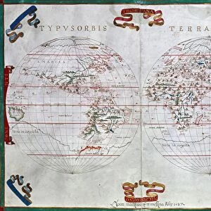
Canvas Print : Map of the Magellan Straits, Patagonia, from the Mercator Atlas pub


![]()
Canvas Prints from Fine Art Finder
Map of the Magellan Straits, Patagonia, from the Mercator Atlas pub
STC101842 Map of the Magellan Straits, Patagonia, from the Mercator Atlas pub. by Jodocus Hondius (1563-1612) Amsterdam, 1606 (engraving) by Dutch School, (17th century); Private Collection; The Stapleton Collection; Dutch, out of copyright
Media ID 22801918
© The Stapleton Collection / Bridgeman Images
Antarctic Chile Compass Tierra Del Fuego Upside Down
20"x16" (51x41cm) Canvas Print
Discover the wonders of exploration history with our stunning Canvas Print of the Map of the Magellan Straits, Patagonia, from the Mercator Atlas pub. by Bridgeman Images. This exquisite piece, taken from the 1606 engraving by Dutch School artist Jodocus Hondius, showcases the intricate detail and beauty of the Patagonian region as it was once charted. Add an element of historical charm to your home or office decor with this captivating canvas print, sure to spark conversation and inspire curiosity.
Delivered stretched and ready to hang our premium quality canvas prints are made from a polyester/cotton blend canvas and stretched over a 1.25" (32mm) kiln dried knot free wood stretcher bar. Packaged in a plastic bag and secured to a cardboard insert for safe transit.
Canvas Prints add colour, depth and texture to any space. Professionally Stretched Canvas over a hidden Wooden Box Frame and Ready to Hang
Estimated Product Size is 50.8cm x 40.6cm (20" x 16")
These are individually made so all sizes are approximate
Artwork printed orientated as per the preview above, with landscape (horizontal) orientation to match the source image.
FEATURES IN THESE COLLECTIONS
> Arts
> Artists
> H
> Jodocus Hondius
> Maps and Charts
> Related Images
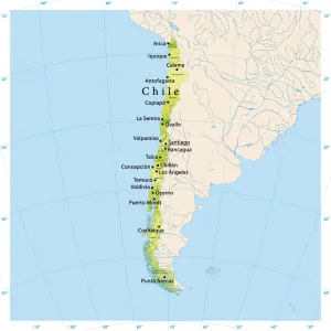
> South America
> Chile
> Maps
> South America
> Chile
> Related Images
> South America
> Related Images
> Fine Art Finder
> Artists
> Alexander Jamieson
> Fine Art Finder
> Artists
> Dutch School
> Fine Art Finder
> Maps (celestial & Terrestrial)
EDITORS COMMENTS
This print showcases a historical map titled "Map of the Magellan Straits, Patagonia" from the renowned Mercator Atlas published by Jodocus Hondius in Amsterdam in 1606. Created by an anonymous Dutch artist during the 17th century, this engraving offers a fascinating glimpse into the exploration and cartography of that era. The map depicts the intricate network of waterways known as the Magellan Straits, located in Patagonia at the tip of South America. The detailed representation highlights various geographical features such as Tierra del Fuego and its surrounding islands. Interestingly, this particular map is oriented upside down compared to modern conventions, adding an intriguing twist to its historical significance. With its delicate engravings and meticulous attention to detail, this artwork captures not only the technical expertise but also the spirit of adventure that characterized early explorations. It serves as a testament to humanity's relentless quest for knowledge and discovery. Now part of a private collection known as The Stapleton Collection, this rare piece provides viewers with a unique opportunity to delve into our past and appreciate how far we have come in understanding our world. As it is out of copyright, it continues to inspire curiosity about distant lands while reminding us of our shared human heritage.
MADE IN THE USA
Safe Shipping with 30 Day Money Back Guarantee
FREE PERSONALISATION*
We are proud to offer a range of customisation features including Personalised Captions, Color Filters and Picture Zoom Tools
SECURE PAYMENTS
We happily accept a wide range of payment options so you can pay for the things you need in the way that is most convenient for you
* Options may vary by product and licensing agreement. Zoomed Pictures can be adjusted in the Cart.