Home > Maps and Charts > Early Maps
Jigsaw Puzzle : Atlantean Continent Map


![]()
Jigsaw Puzzles from Mary Evans Picture Library
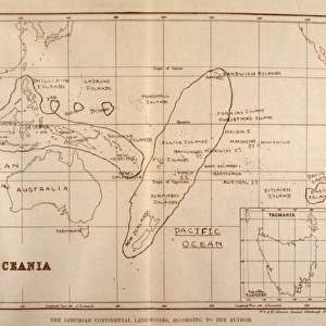
Atlantean Continent Map
Map of the Atlantean Continent showing the extent of the Ice Age
Mary Evans Picture Library makes available wonderful images created for people to enjoy over the centuries
Media ID 573538
© Mary Evans Picture Library 2015 - https://copyrighthub.org/s0/hub1/creation/maryevans/MaryEvansPictureID/10008429
1933 Atlantis Continent Extent Folk Lore Mythical Places
Jigsaw Puzzle (252 Pieces)
Discover the lost world of Atlantis with our captivating Atlantean Continent Map jigsaw puzzle from Media Storehouse, in partnership with Mary Evans Prints Online. This intriguing puzzle, depicting an ancient map showing the extent of the Ice Age, is the perfect addition to your collection or a thoughtful gift for puzzle enthusiasts. Immerse yourself in the mystery and wonder of the Atlantean civilization as you piece together this detailed and intricately designed puzzle. With a rich, vibrant image, this puzzle promises hours of engaging entertainment, challenging your mind and sharpening your focus. The Media Storehouse range of jigsaw puzzles is known for its high-quality, durable pieces and beautiful, intricately detailed designs. Each puzzle is meticulously crafted to provide an enjoyable and rewarding puzzle-solving experience. Unlock the secrets of the Atlantean Continent and transport yourself to a world of adventure and discovery with the Atlantean Continent Map jigsaw puzzle from Media Storehouse.
Made in the USA, 252-piece puzzles measure 11" x 14" (27.9 x 35.5 cm). Every puzzle is meticulously printed on glossy photo paper, which has a strong 1.33 mm thickness. Delivered in a black storage cardboard box, these puzzles are both stylish and practical. (Note: puzzles contain small parts and are not suitable for children under 3 years of age.)
Jigsaw Puzzles are an ideal gift for any occasion
Estimated Product Size is 35.6cm x 28cm (14" x 11")
These are individually made so all sizes are approximate
Artwork printed orientated as per the preview above, with landscape (horizontal) orientation to match the source image.
FEATURES IN THESE COLLECTIONS
> Maps and Charts
> Early Maps
> Maps and Charts
> Related Images
EDITORS COMMENTS
This print depicts the Atlantean Continent Map, a mythical representation of the ancient civilization believed to have existed before its supposed sinking into the Atlantic Ocean. The map, dated back to 1933, illustrates the extent of the Ice Age as it relates to Atlantis, adding an intriguing layer of historical and folk lore to the legend. At the heart of the map lies the Atlantean continent, surrounded by the Atlantic and Indian Oceans, the Mediterranean Sea, and the Arctic Ocean. The map reveals a vast landmass, larger than any known continent today, with intricate details of its geographical features, including mountains, rivers, lakes, and forests. The Ice Age's impact on Atlantis is evident in the map's chilling depiction of glaciers and icy expanses, suggesting that the civilization thrived during a colder climate than previously thought. The map also highlights various places of historical significance, such as the Temple of Poseidon, the Palace of Atlas, and the famous Crystal Waters. The Atlantean Continent Map is a fascinating blend of history and mythology, offering a glimpse into the rich folklore surrounding the lost civilization of Atlantis. Its detailed illustration of the Ice Age's extent adds an intriguing layer to the legend, leaving us to ponder the possibilities of an advanced civilization that once flourished in a colder climate. This print is a must-have for anyone interested in ancient civilizations, mythology, or cartography.
MADE IN THE USA
Safe Shipping with 30 Day Money Back Guarantee
FREE PERSONALISATION*
We are proud to offer a range of customisation features including Personalised Captions, Color Filters and Picture Zoom Tools
SECURE PAYMENTS
We happily accept a wide range of payment options so you can pay for the things you need in the way that is most convenient for you
* Options may vary by product and licensing agreement. Zoomed Pictures can be adjusted in the Cart.