Framed Print > Maps and Charts > Early Maps
Framed Print : Atlantean Continent Map


![]()
Framed Photos from Mary Evans Picture Library
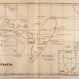
Atlantean Continent Map
Map of the Atlantean Continent showing the extent of the Ice Age
Mary Evans Picture Library makes available wonderful images created for people to enjoy over the centuries
Media ID 573538
© Mary Evans Picture Library 2015 - https://copyrighthub.org/s0/hub1/creation/maryevans/MaryEvansPictureID/10008429
1933 Atlantis Continent Extent Folk Lore Mythical Places
12"x10" Modern Frame
Discover the mystical world of Atlantis with our stunning Framed Prints from Media Storehouse, featuring an exclusive Atlantean Continent Map from Mary Evans Prints Online. This captivating map showcases the extent of the Ice Age, transporting you to a time when ancient civilizations thrived in a world dramatically different from our own. Our Framed Prints are meticulously crafted with high-quality materials, ensuring a vibrant and long-lasting display. Bring the enigma of Atlantis into your home or office, and ignite the imagination of all who enter with this awe-inspiring addition to your decor.
10x8 Print in an MDF Wooden Frame with 180 gsm Satin Finish Paper. Glazed using shatter proof thin plexi glass. Frame thickness is 1 inch and depth 0.75 inch. Fluted cardboard backing held with clips. Supplied ready to hang with sawtooth hanger and rubber bumpers. Spot clean with a damp cloth. Packaged foam wrapped in a card.
Contemporary Framed and Mounted Prints - Professionally Made and Ready to Hang
Estimated Image Size (if not cropped) is 25.4cm x 25.4cm (10" x 10")
Estimated Product Size is 30.5cm x 25.4cm (12" x 10")
These are individually made so all sizes are approximate
Artwork printed orientated as per the preview above, with landscape (horizontal) or portrait (vertical) orientation to match the source image.
FEATURES IN THESE COLLECTIONS
> Maps and Charts
> Early Maps
> Maps and Charts
> Related Images
EDITORS COMMENTS
This print depicts the Atlantean Continent Map, a mythical representation of the ancient civilization believed to have existed before its supposed sinking into the Atlantic Ocean. The map, dated back to 1933, illustrates the extent of the Ice Age as it relates to Atlantis, adding an intriguing layer of historical and folk lore to the legend. At the heart of the map lies the Atlantean continent, surrounded by the Atlantic and Indian Oceans, the Mediterranean Sea, and the Arctic Ocean. The map reveals a vast landmass, larger than any known continent today, with intricate details of its geographical features, including mountains, rivers, lakes, and forests. The Ice Age's impact on Atlantis is evident in the map's chilling depiction of glaciers and icy expanses, suggesting that the civilization thrived during a colder climate than previously thought. The map also highlights various places of historical significance, such as the Temple of Poseidon, the Palace of Atlas, and the famous Crystal Waters. The Atlantean Continent Map is a fascinating blend of history and mythology, offering a glimpse into the rich folklore surrounding the lost civilization of Atlantis. Its detailed illustration of the Ice Age's extent adds an intriguing layer to the legend, leaving us to ponder the possibilities of an advanced civilization that once flourished in a colder climate. This print is a must-have for anyone interested in ancient civilizations, mythology, or cartography.
MADE IN THE USA
Safe Shipping with 30 Day Money Back Guarantee
FREE PERSONALISATION*
We are proud to offer a range of customisation features including Personalised Captions, Color Filters and Picture Zoom Tools
SECURE PAYMENTS
We happily accept a wide range of payment options so you can pay for the things you need in the way that is most convenient for you
* Options may vary by product and licensing agreement. Zoomed Pictures can be adjusted in the Cart.