Home > Arts > Pop art > Contemporary art > Fine art gallery
Jigsaw Puzzle : 6th century World Map


![]()
Jigsaw Puzzles from Mary Evans Picture Library
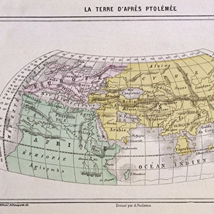
6th century World Map
6th century World Map according to Cosmas Indicopleustes & his contemporaries
Mary Evans Picture Library makes available wonderful images created for people to enjoy over the centuries
Media ID 570610
© Mary Evans Picture Library 2015 - https://copyrighthub.org/s0/hub1/creation/maryevans/MaryEvansPictureID/10001212
Jigsaw Puzzle (252 Pieces)
Discover the mysteries of the ancient world with our captivating collection of jigsaw puzzles from Media Storehouse. This intriguing puzzle showcases a fascinating 6th century World Map, as depicted by Mary Evans Picture Library from Mary Evans Prints Online. Based on the descriptions in Cosmas Indicopleustes' text, this map offers a unique perspective of the world as it was known during that time. Piece together the intricate details of continents, oceans, and mythical lands, transporting yourself back in history. Immerse yourself in the adventure of piecing together this captivating puzzle, perfect for history enthusiasts, puzzle lovers, or anyone seeking a challenging and educational pastime.
Made in the USA, 252-piece puzzles measure 11" x 14" (27.9 x 35.5 cm). Every puzzle is meticulously printed on glossy photo paper, which has a strong 1.33 mm thickness. Delivered in a black storage cardboard box, these puzzles are both stylish and practical. (Note: puzzles contain small parts and are not suitable for children under 3 years of age.)
Jigsaw Puzzles are an ideal gift for any occasion
Estimated Product Size is 35.6cm x 28cm (14" x 11")
These are individually made so all sizes are approximate
Artwork printed orientated as per the preview above, with landscape (horizontal) orientation to match the source image.
FEATURES IN THESE COLLECTIONS
> Arts
> Contemporary art
> Arts
> Pop art
> Contemporary art
> Contemporary art gallery
> Arts
> Pop art
> Contemporary art
> Fine art gallery
> Maps and Charts
> Early Maps
> Maps and Charts
> Related Images
> Maps and Charts
> World
EDITORS COMMENTS
This stunning print captures a glimpse into the past with a 6th century World Map according to Cosmas Indicopleustes and his contemporaries. The intricate details and historical significance of this map are truly mesmerizing, showcasing the world as it was perceived centuries ago.
As we study this ancient map, we can see how different cultures viewed the world around them and how their geographical knowledge influenced their perceptions. From distant lands to mythical creatures, every corner of this map tells a story of exploration and discovery.
Cosmas Indicopleustes, a Greek monk and geographer, created this map based on his own travels and observations. His work is a testament to the curiosity and ingenuity of early cartographers who sought to understand the vast expanse of our planet.
Looking at this 6th century World Map is like taking a journey through time, allowing us to connect with the past in a tangible way. It serves as a reminder of how far we have come in terms of mapping technology and scientific understanding.
Mary Evans Picture Library has beautifully preserved this piece of history for all to admire. It is not just a map; it is a window into another era that continues to fascinate us today.
MADE IN THE USA
Safe Shipping with 30 Day Money Back Guarantee
FREE PERSONALISATION*
We are proud to offer a range of customisation features including Personalised Captions, Color Filters and Picture Zoom Tools
SECURE PAYMENTS
We happily accept a wide range of payment options so you can pay for the things you need in the way that is most convenient for you
* Options may vary by product and licensing agreement. Zoomed Pictures can be adjusted in the Cart.