Jigsaw Puzzle > Universal Images Group (UIG) > Universal Images Group > Satellite and Aerial > Planet Observer 4
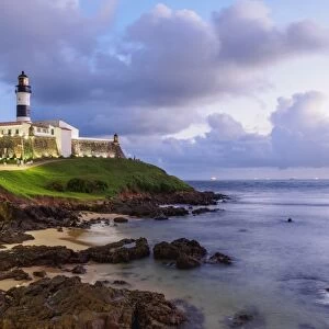
Jigsaw Puzzle : State of Bahia, Brazil, Relief Map


![]()
Jigsaw Puzzles from Universal Images Group (UIG)
State of Bahia, Brazil, Relief Map
Relief map of the State of Bahia, Brazil. This image was compiled from data acquired by LANDSAT 5 & 7 satellites combined with elevation data
Universal Images Group (UIG) manages distribution for many leading specialist agencies worldwide
Media ID 9619213
© Planet Observer/UIG
Brazil Coastline Relief Map Shore South America State Bahia Salvador Satellite View
Jigsaw Puzzle (520 Pieces)
Discover the intricacies of geography with our captivating State of Bahia, Brazil Jigsaw Puzzle from Media Storehouse. This intricately detailed puzzle, featuring an aerial relief map of the State of Bahia, Brazil, is a must-have for geography enthusiasts and puzzle lovers alike. Compiled from satellite data acquired by LANDSAT 5 & 7, this puzzle provides an accurate representation of the diverse topography of the region. Engage in a challenging yet rewarding experience as you piece together the various landscapes, rivers, and mountains of Bahia, Brazil. Immerse yourself in the beauty of the earth and expand your knowledge with every completed puzzle piece.
Made in the USA, 520-piece puzzles measure 16" x 20" (40.6 x 50.8 cm). Every puzzle is meticulously printed on glossy photo paper, which has a strong 1.33 mm thickness. Delivered in a black storage cardboard box, these puzzles are both stylish and practical. (Note: puzzles contain small parts and are not suitable for children under 3 years of age.)
Jigsaw Puzzles are an ideal gift for any occasion
Estimated Product Size is 40.5cm x 50.8cm (15.9" x 20")
These are individually made so all sizes are approximate
Artwork printed orientated as per the preview above, with landscape (horizontal) or portrait (vertical) orientation to match the source image.
EDITORS COMMENTS
This print showcases the stunning relief map of the State of Bahia, Brazil. With intricate details and vibrant colors, this image provides a unique perspective on the topography of this South American state. Compiled from data acquired by LANDSAT 5 & 7 satellites combined with elevation data, it offers an accurate representation of Bahia's physical geography. The photograph captures the diverse landscape that characterizes Bahia, from its picturesque coastline to its inland regions. The vertical composition allows viewers to appreciate the state's vastness and varied terrain in great detail. No people are present in the image, emphasizing the untouched beauty and natural splendor of this Brazilian paradise. Salvador, Bahia's capital city, is prominently featured on this relief map. Its location along the coast adds another layer of intrigue to this already fascinating depiction. Cartography enthusiasts will be captivated by how effortlessly this print combines scientific precision with artistic flair. Whether you are a geography enthusiast or simply drawn to breathtaking imagery, this print is sure to transport you into a world where nature reigns supreme. It serves as a reminder of our planet's awe-inspiring landscapes and invites us to explore and appreciate their magnificence further
MADE IN THE USA
Safe Shipping with 30 Day Money Back Guarantee
FREE PERSONALISATION*
We are proud to offer a range of customisation features including Personalised Captions, Color Filters and Picture Zoom Tools
SECURE PAYMENTS
We happily accept a wide range of payment options so you can pay for the things you need in the way that is most convenient for you
* Options may vary by product and licensing agreement. Zoomed Pictures can be adjusted in the Cart.