Framed Print > Universal Images Group (UIG) > Universal Images Group > Satellite and Aerial > Planet Observer 4
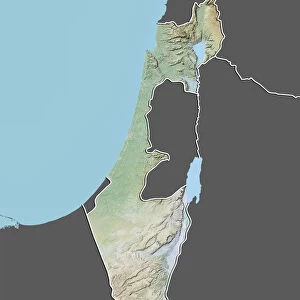
Framed Print : State of Bahia, Brazil, Relief Map


![]()
Framed Photos from Universal Images Group (UIG)
State of Bahia, Brazil, Relief Map
Relief map of the State of Bahia, Brazil. This image was compiled from data acquired by LANDSAT 5 & 7 satellites combined with elevation data
Universal Images Group (UIG) manages distribution for many leading specialist agencies worldwide
Media ID 9619213
© Planet Observer/UIG
Brazil Coastline Relief Map Shore South America State Bahia Salvador Satellite View
12"x10" Modern Frame
Discover the beauty and complexity of the geography of Bahia, Brazil, with our Framed Print from Media Storehouse. This exquisite piece showcases a relief map of the State of Bahia, meticulously created using data from LANDSAT 5 & 7 satellites and elevation information. The intricately detailed topography comes alive in this stunning representation, making it an excellent addition to any home or office space. Experience the power of visual storytelling and bring a piece of the world into your space with our Framed Print of the State of Bahia, Brazil. #Bahia #Brazil #ReliefMap #Geography #HomeDecor
10x8 Print in an MDF Wooden Frame with 180 gsm Satin Finish Paper. Glazed using shatter proof thin plexi glass. Frame thickness is 1 inch and depth 0.75 inch. Fluted cardboard backing held with clips. Supplied ready to hang with sawtooth hanger and rubber bumpers. Spot clean with a damp cloth. Packaged foam wrapped in a card.
Contemporary Framed and Mounted Prints - Professionally Made and Ready to Hang
Estimated Image Size (if not cropped) is 25.4cm x 25.4cm (10" x 10")
Estimated Product Size is 25.4cm x 30.5cm (10" x 12")
These are individually made so all sizes are approximate
Artwork printed orientated as per the preview above, with landscape (horizontal) or portrait (vertical) orientation to match the source image.
EDITORS COMMENTS
This print showcases the stunning relief map of the State of Bahia, Brazil. With intricate details and vibrant colors, this image provides a unique perspective on the topography of this South American state. Compiled from data acquired by LANDSAT 5 & 7 satellites combined with elevation data, it offers an accurate representation of Bahia's physical geography. The photograph captures the diverse landscape that characterizes Bahia, from its picturesque coastline to its inland regions. The vertical composition allows viewers to appreciate the state's vastness and varied terrain in great detail. No people are present in the image, emphasizing the untouched beauty and natural splendor of this Brazilian paradise. Salvador, Bahia's capital city, is prominently featured on this relief map. Its location along the coast adds another layer of intrigue to this already fascinating depiction. Cartography enthusiasts will be captivated by how effortlessly this print combines scientific precision with artistic flair. Whether you are a geography enthusiast or simply drawn to breathtaking imagery, this print is sure to transport you into a world where nature reigns supreme. It serves as a reminder of our planet's awe-inspiring landscapes and invites us to explore and appreciate their magnificence further
MADE IN THE USA
Safe Shipping with 30 Day Money Back Guarantee
FREE PERSONALISATION*
We are proud to offer a range of customisation features including Personalised Captions, Color Filters and Picture Zoom Tools
SECURE PAYMENTS
We happily accept a wide range of payment options so you can pay for the things you need in the way that is most convenient for you
* Options may vary by product and licensing agreement. Zoomed Pictures can be adjusted in the Cart.