Home > Asia > India > Maps
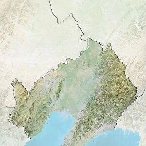
State of Bihar, India, Relief Map

![]()
Wall Art and Photo Gifts from Universal Images Group (UIG)
State of Bihar, India, Relief Map
Relief map of the State of Bihar, India. This image was compiled from data acquired by LANDSAT 5 & 7 satellites combined with elevation data
Universal Images Group (UIG) manages distribution for many leading specialist agencies worldwide
Media ID 9619225
© Planet Observer/UIG
India Relief Map State Bihar Satellite View
FEATURES IN THESE COLLECTIONS
> Universal Images Group (UIG)
> Universal Images Group
> Satellite and Aerial
> Planet Observer 4
EDITORS COMMENTS
This stunning print showcases the intricate and diverse topography of the State of Bihar, India. The relief map, compiled from data acquired by LANDSAT 5 & 7 satellites combined with elevation data, offers a mesmerizing aerial view of this region's physical geography. With its vibrant colors and detailed cartography, this image provides an immersive experience into Bihar's natural beauty. Stretching across the horizontal frame, the relief map captures Bihar's varied landscapes in remarkable detail. From soaring mountain ranges to sprawling plains and winding rivers, every contour is meticulously depicted. This visual representation allows us to appreciate the state's geographical features that have shaped its history and culture. The absence of people in this photograph emphasizes the focus on nature itself. It invites viewers to explore Bihar's untamed wilderness without any distractions or human interference. As we gaze upon this awe-inspiring satellite view, we are reminded of our planet's incredible diversity and how it continues to inspire us. Whether you are an avid traveler or simply fascinated by maps and geography, this print from Universal Images Group (UIG) will surely captivate your imagination. Its non-commercial use ensures that it can be appreciated purely for its artistic value while serving as a reminder of the wonders that lie beyond our everyday lives.
MADE IN THE USA
Safe Shipping with 30 Day Money Back Guarantee
FREE PERSONALISATION*
We are proud to offer a range of customisation features including Personalised Captions, Color Filters and Picture Zoom Tools
SECURE PAYMENTS
We happily accept a wide range of payment options so you can pay for the things you need in the way that is most convenient for you
* Options may vary by product and licensing agreement. Zoomed Pictures can be adjusted in the Cart.