Home > North America > United States of America > Maps
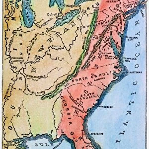
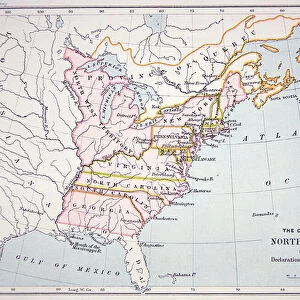
Map Of The Colonies Of North America At The Declaration Of Independence

![]()
Wall Art and Photo Gifts from Universal Images Group (UIG)
Map Of The Colonies Of North America At The Declaration Of Independence
Universal Images Group (UIG) manages distribution for many leading specialist agencies worldwide
Media ID 20165219
© Universal Images Group
18th America American Century Colonies Declaration Eighteenth Geographical Geography Independence North States United
FEATURES IN THESE COLLECTIONS
> North America
> United States of America
> Maps
> Universal Images Group (UIG)
> History
> Historical Maps
EDITORS COMMENTS
This print showcases the intricate "Map Of The Colonies Of North America At The Declaration Of Independence" during the 18th century. A testament to the birth of a nation, this map visually narrates the historical context surrounding the United States' declaration of independence from British rule. With its detailed cartography and geographical accuracy, it provides a fascinating glimpse into how these colonies were organized at that pivotal moment in history. The map's vibrant colors and fine craftsmanship transport us back to a time when each colony had its unique identity within a larger American landscape. From Massachusetts to Georgia, we can trace the borders and boundaries that defined these early settlements. It is remarkable to witness how this diverse collection of colonies eventually united under one flag. As we examine this piece closely, we are reminded of the immense courage and determination displayed by those who fought for freedom during this era. This map serves as an invaluable resource for historians, educators, and enthusiasts alike – shedding light on both our shared heritage and individual regional histories. Universal History Archive has once again preserved an essential artifact through their lens, allowing us to appreciate not only its historical significance but also its aesthetic beauty. This print captures more than just lines on paper; it encapsulates a defining moment in American history that shaped our nation's destiny forever.
MADE IN THE USA
Safe Shipping with 30 Day Money Back Guarantee
FREE PERSONALISATION*
We are proud to offer a range of customisation features including Personalised Captions, Color Filters and Picture Zoom Tools
SECURE PAYMENTS
We happily accept a wide range of payment options so you can pay for the things you need in the way that is most convenient for you
* Options may vary by product and licensing agreement. Zoomed Pictures can be adjusted in the Cart.