Home > Europe > United Kingdom > England > London > Boroughs > Harrow
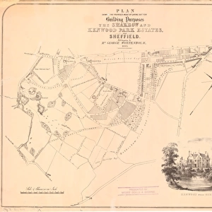
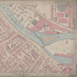
Ordnance Survey Map, Bernard Road area, 1890 (sheet no. Yorkshire No. 294.8.18)
")
![]()
Wall Art and Photo Gifts from Sheffield City Archives
Ordnance Survey Map, Bernard Road area, 1890 (sheet no. Yorkshire No. 294.8.18)
This map features
Top left: Broad Street, Shrewsbury Works (metal) (in margin), Park Plate Works (in margin), Old Street, High Street Lane, Crown Alley Lane, Low Street, New Street Lane, Lister's Row, Long Steps, Orchard Hill, Blast Lane, Bard Street, Crown Alley, Duke Street, East Street, Stepney Street, Plumper's Inn, Old Harrow Inn, Golden Cock Inn, Post Office, Old Crown Inn, Smithy, Old Crown and Cushion Public House, Feathers Inn, and Midland Railway.
Top right: Bernard Street, Staniforth Lane, Ruben's Street, Park Hill Lane, [St John's] Grave Yard (boundaries: Park Hill, St John's Walk, St John's road), Hyde Park Drill Ground [for 1st Volunteer Battalion, York and Lancaster Regiment], Wybourn Road, St. John's Road, St. John's Walk, Bigod Street, St. John's Vicarage, and Hospital Tavern.
Bottom left: Bard Street, Crown Alley, Duke Street, East Street, Stepney Street, Plumper's Inn, Duke Street Lane, Gilbert Street, Lord Street, [Park] School (Boys) (on Duke Street), Playground, Foundry Yard, Anson Street, School Street, St. John's School (Boys and Girls), playground, St. John's School (Infants), playground, School Lane, School Hill, Cooper's Yard, and Shale's Square.
Bottom right: Bernard Street, Staniforth Lane, Ruben's Street, Park Hill Lane, Hyde Park, St. John's Road, Ruben's Lane, Drill Hall (1st Volunteer Battalion, York and Lancaster Regiment), Weigh Lane, Rough Bank, Simonite Lane, Hyde Park Quarry, and Chequers Public House.
Surveyed, 1889. First edition, 1890. Reprint, 1896.
Dimensions of original: 77 x 102 cm.
Scale 10.56 feet : 1 mile [1:500]
From an original at Sheffield Libraries: q00084 (sheet no. Yorkshire No. 294.8.18)
Sheffield City Archives and Local Studies Library has an unrivalled collection of images of Sheffield, England
Media ID 33302281
© Sheffield City Council - All Rights Reserved
Old Map Ordnance Survey Os Map Sheffield
FEATURES IN THESE COLLECTIONS
> Animals
> Insects
> Hemiptera
> Hall Scale
> Animals
> Mammals
> Cercopithecidae
> Drill
> Europe
> United Kingdom
> England
> London
> Boroughs
> Harrow
> Europe
> United Kingdom
> England
> London
> Sights
> Hyde Park
> Europe
> United Kingdom
> England
> Yorkshire
> Hyde Park
> Europe
> United Kingdom
> England
> Yorkshire
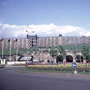
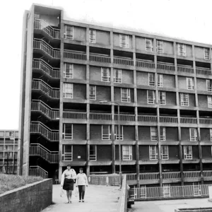
> Park Hill
> Europe
> United Kingdom
> England
> Yorkshire
> Sheffield
> Europe
> United Kingdom
> England
> Yorkshire
> Street
> Maps and Charts
> Related Images
> Sheffield City Archives
> Maps and Plans
> Sheffield OS maps
EDITORS COMMENTS
This print showcases an Ordnance Survey Map of the Bernard Road area in 1890. The map, sheet no. Yorkshire No. 294.8.18, provides a fascinating glimpse into the past and offers a wealth of information about the surrounding streets and landmarks. In the top left corner, we can identify various notable locations such as Broad Street, Shrewsbury Works (metal), Park Plate Works, Old Street, High Street Lane, Crown Alley Lane, Low Street, New Street Lane, Lister’s Row, Long Steps, Orchard Hill, Blast Lane and many more. Additionally, it highlights significant establishments like Post Office and Midland Railway. Moving to the top right section of the map reveals Bernard Street along with Staniforth Lane and Ruben’s Street nearby. Other points of interest include Hyde Park Drill Ground for 1st Volunteer Battalion York and Lancaster Regiment), St John's Grave Yard bounded by Park Hill Walk and St John's Road) as well as Wybourn Road. The bottom left portion features Bard Street alongside Duke Street and East Street among others. It also pinpoints several educational institutions including [Park] School (Boys), St John's School for Boys & Girls as well as St John's School for Infants. Lastly on the bottom right side lies Bernard street again along with Staniforth lane while highlighting Hyde Park Quarry and Chequers Public House in close proximity. Surveyed in 1889 with its first edition published in 1890 followed by a reprint in 1896; this original map measures at an impressive size of 77 x102 cm offering intricate details at a scale of 10.56 feet:1 mile [1:500]. Preserved within Sheffield Libraries under reference q00084 (sheet no. Yorkshire No. 2948-18), this historical gem from Sheffield City Archives is not intended for commercial use but serves as a valuable resource for those interested in exploring the city's rich past.
MADE IN THE USA
Safe Shipping with 30 Day Money Back Guarantee
FREE PERSONALISATION*
We are proud to offer a range of customisation features including Personalised Captions, Color Filters and Picture Zoom Tools
SECURE PAYMENTS
We happily accept a wide range of payment options so you can pay for the things you need in the way that is most convenient for you
* Options may vary by product and licensing agreement. Zoomed Pictures can be adjusted in the Cart.