Premium Framed Print > Europe > United Kingdom > England > Sussex > Upper Beeding
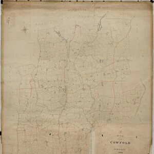
Premium Framed Print : Upper Beeding Tithe Map, 1842


![]()
Framed Photos from West Sussex County Council
Upper Beeding Tithe Map, 1842
By J. & E. Smith, Surveyors. 26.6 in. to 1 m. Original Map Size 112in. × 94in.
Tithe Award Map Collection
West Sussex Record Office Ref No: TD/W165
West Sussex County Council Record Office contains a fascinating history of the county of West Sussex, England
Media ID 7915654
© West Sussex County Council - All Rights Reserved
1840s Historical Mapping Parish
14"x16" Premium Frame
Contemporary style Premium Wooden Frame with 8"x10" Print. Complete with 2" White Mat and 1.25" thick MDF frame. Printed on 260 gsm premium paper. Glazed with shatter proof UV coated acrylic glass. Backing is paper covered backing with rubber bumpers. Supplied ready to hang with a pre-installed sawtooth/wire hanger. Care Instructions: Spot clean with a damp cloth. Securely packaged in a clear plastic bag and envelope in a reinforced cardboard shipper
FSC Real Wood Frame and Double Mounted with White Conservation Mountboard - Professionally Made and Ready to Hang
Estimated Image Size (if not cropped) is 20.3cm x 25.4cm (8" x 10")
Estimated Product Size is 35.6cm x 40.6cm (14" x 16")
These are individually made so all sizes are approximate
Artwork printed orientated as per the preview above, with portrait (vertical) orientation to match the source image.
FEATURES IN THESE COLLECTIONS
> Europe
> United Kingdom
> England
> Sussex
> Related Images
> Europe
> United Kingdom
> England
> Sussex
> Upper Beeding
> Europe
> United Kingdom
> England
> West Sussex
> Related Images
> Maps and Charts
> Early Maps
> Maps and Charts
> Related Images
> West Sussex County Council
> West Sussex Record Office
> Tithe Award Maps, 1808-1859
EDITORS COMMENTS
This print showcases the Upper Beeding Tithe Map from 1842, a remarkable piece of historical mapping that offers a glimpse into the past. Created by esteemed surveyors J. & E. Smith, this map is an impressive feat of cartography with its original size measuring an astounding 112 inches by 94 inches. The Upper Beeding Tithe Map holds immense significance as it provides valuable insights into the parish during the 1840s. It serves as a window to a bygone era, allowing us to explore and understand how this area in West Sussex was structured and utilized at that time. Preserved within the renowned Tithe Award Map Collection at the West Sussex Record Office, this print represents an invaluable resource for researchers, historians, and anyone interested in delving deep into local history. Its meticulous details offer a comprehensive overview of land ownership, boundaries, and usage patterns prevalent during that period. It is important to note that this caption focuses solely on providing information about the photograph itself and does not mention any commercial use or reference to any specific company associated with it. The intent is solely to highlight the historical significance of this particular map within West Sussex County Council's collection for educational purposes.
MADE IN THE USA
Safe Shipping with 30 Day Money Back Guarantee
FREE PERSONALISATION*
We are proud to offer a range of customisation features including Personalised Captions, Color Filters and Picture Zoom Tools
SECURE PAYMENTS
We happily accept a wide range of payment options so you can pay for the things you need in the way that is most convenient for you
* Options may vary by product and licensing agreement. Zoomed Pictures can be adjusted in the Cart.