Premium Framed Print > Animals > Fishes > G > Grouper
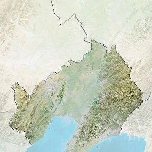
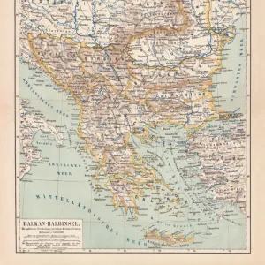
Premium Framed Print : Montenegro, Relief Map With Border and Mask


![]()
Framed Photos From Universal Images Group (UIG)
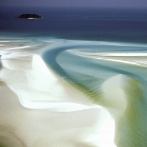
Montenegro, Relief Map With Border and Mask
Relief map of Montenegro (with border and mask). This image was compiled from data acquired by landsat 5 & 7 satellites combined with elevation data
Universal Images Group (UIG) manages distribution for many leading specialist agencies worldwide
Media ID 9613243
© Planet Observer/UIG
Adriatic Sea Balkans Coastline Montenegro Relief Map Shore Podgorica Satellite View
14"x16" Premium Frame
Contemporary style Premium Wooden Frame with 8"x10" Print. Complete with 2" White Mat and 1.25" thick MDF frame. Printed on 260 gsm premium paper. Glazed with shatter proof UV coated acrylic glass. Backing is paper covered backing with rubber bumpers. Supplied ready to hang with a pre-installed sawtooth/wire hanger. Care Instructions: Spot clean with a damp cloth. Securely packaged in a clear plastic bag and envelope in a reinforced cardboard shipper
FSC Real Wood Frame and Double Mounted with White Conservation Mountboard - Professionally Made and Ready to Hang
Estimated Image Size (if not cropped) is 20.3cm x 25.4cm (8" x 10")
Estimated Product Size is 35.6cm x 40.6cm (14" x 16")
These are individually made so all sizes are approximate
Artwork printed orientated as per the preview above, with portrait (vertical) orientation to match the source image.
FEATURES IN THESE COLLECTIONS
> Animals
> Fishes
> G
> Grouper
> Europe
> Montenegro
> Maps
> Europe
> Montenegro
> Podgorica
> Europe
> Montenegro
> Related Images
> Maps and Charts
> Montenegro
> Maps and Charts
> Related Images
> Universal Images Group (UIG)
> Universal Images Group
> Satellite and Aerial
> Planet Observer 4
EDITORS COMMENTS
This stunning print captures the breathtaking beauty of Montenegro, a hidden gem nestled in the Balkans. The image showcases a relief map of Montenegro, meticulously compiled from data acquired by Landsat 5 & 7 satellites combined with elevation data. With its intricate details and vibrant colors, this print offers a unique perspective on the physical geography of Montenegro. The relief map reveals the diverse topography of this enchanting country, showcasing its majestic mountains, rolling hills, and picturesque coastline along the Adriatic Sea. From Podgorica to the shoreline, every inch of Montenegro's landscape is beautifully depicted in this image. As you gaze at this photo print, you can almost feel yourself transported to Montenegro's rugged terrain and immerse yourself in its natural wonders. The absence of people allows for an uninterrupted view that highlights the untouched beauty and tranquility that define this European destination. Whether you are an avid traveler or simply appreciate cartography and photography as art forms, this print will undoubtedly captivate your imagination. It serves as a reminder of nature's grandeur and invites you to explore all that Montenegro has to offer – from its charming coastal towns to its untamed wilderness
MADE IN THE USA
Safe Shipping with 30 Day Money Back Guarantee
FREE PERSONALISATION*
We are proud to offer a range of customisation features including Personalised Captions, Color Filters and Picture Zoom Tools
SECURE PAYMENTS
We happily accept a wide range of payment options so you can pay for the things you need in the way that is most convenient for you
* Options may vary by product and licensing agreement. Zoomed Pictures can be adjusted in the Basket.