Premium Framed Print > Europe > Finland > Related Images
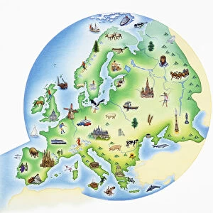
Premium Framed Print : Map of Nordic countries and Lapland, by Olaus Magnus, from Carta Marina, Sea Map, 1539


![]()
Framed Photos from Universal Images Group (UIG)
Map of Nordic countries and Lapland, by Olaus Magnus, from Carta Marina, Sea Map, 1539
Cartography, 16th century. Map of Nordic countries and Lapland. From Carta Marina (Sea Map) by Olaus Magnus, 1539
Universal Images Group (UIG) manages distribution for many leading specialist agencies worldwide
Media ID 9571903
© DEA / M. SEEMULLER
16th Century Coastline Finland Lapland Nautical Vessel River Sailing Boat Transportation Western Script Olaus Magnus
14"x16" Premium Frame
Contemporary style Premium Wooden Frame with 8"x10" Print. Complete with 2" White Mat and 1.25" thick MDF frame. Printed on 260 gsm premium paper. Glazed with shatter proof UV coated acrylic glass. Backing is paper covered backing with rubber bumpers. Supplied ready to hang with a pre-installed sawtooth/wire hanger. Care Instructions: Spot clean with a damp cloth. Securely packaged in a clear plastic bag and envelope in a reinforced cardboard shipper
FSC Real Wood Frame and Double Mounted with White Conservation Mountboard - Professionally Made and Ready to Hang
Estimated Image Size (if not cropped) is 20.3cm x 25.4cm (8" x 10")
Estimated Product Size is 35.6cm x 40.6cm (14" x 16")
These are individually made so all sizes are approximate
Artwork printed orientated as per the preview above, with portrait (vertical) orientation to match the source image.
FEATURES IN THESE COLLECTIONS
> Europe
> Finland
> Related Images
> Universal Images Group (UIG)
> Art
> Painting, Sculpture & Prints
> Cartography
EDITORS COMMENTS
This print showcases a remarkable piece of cartography from the 16th century - the "Map of Nordic countries and Lapland" by Olaus Magnus. Taken from his renowned work, Carta Marina (Sea Map), this intricate map provides a fascinating glimpse into the geographical knowledge and artistic skills of that era. In this studio shot, we see the beautifully preserved map, which highlights not only the Nordic countries but also Lapland. The attention to detail is awe-inspiring as it depicts various elements such as transportation routes, sailing boats navigating through rivers and seas, and even human representations along the coastline. The historical significance of this artwork cannot be overstated. It offers valuable insights into physical geography during that time period while showcasing Olaus Magnus' mastery in cartography. The use of Western script adds another layer of intrigue to this ancient artifact. As we gaze upon this vertical composition, we are transported back in time to an era where exploration and discovery were at their peak. This artful illustration serves as a testament to humanity's thirst for knowledge and adventure. With no people present in the image, our focus is solely on appreciating the craftsmanship behind this extraordinary piece. Whether you are an enthusiast of history or simply captivated by art and craft, this print will undoubtedly enrich your understanding of our past while adding a touch of elegance to any space it adorns.
MADE IN THE USA
Safe Shipping with 30 Day Money Back Guarantee
FREE PERSONALISATION*
We are proud to offer a range of customisation features including Personalised Captions, Color Filters and Picture Zoom Tools
SECURE PAYMENTS
We happily accept a wide range of payment options so you can pay for the things you need in the way that is most convenient for you
* Options may vary by product and licensing agreement. Zoomed Pictures can be adjusted in the Cart.